
Himachal Pradesh topographic map
Interactive map
Click on the map to display elevation.
Himachal Pradesh
Due to extreme variation in elevation, great variation occurs in the climatic conditions of Himachal Pradesh. The climate varies from hot and humid subtropical in the southern tracts to, with more elevation, cold, alpine, and glacial in the northern and eastern mountain ranges. The state's winter capital, Dharamsala receives very heavy rainfall, while areas like Lahaul and Spiti are cold and almost rainless. Broadly, Himachal experiences three seasons: summer, winter, and rainy season. Summer lasts from mid-April until the end of June and most parts become very hot (except in the alpine zone which experiences a mild summer) with the average temperature ranging from 28 to 32 °C (82 to 90 °F). Winter lasts from late November until mid-March. Snowfall is common in alpine tracts. Pollution is affecting the climate of almost all the states of India. Due to steps taken by governments to prevent pollution, Himachal Pradesh has become the first smoke-free state in India which means cooking in the entire state is free of traditional chulhas.
About this map
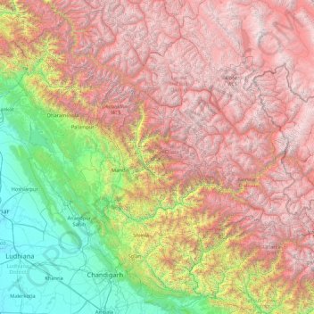
Name: Himachal Pradesh topographic map, elevation, terrain.
Location: Himachal Pradesh, India (30.37717 75.59401 33.25567 79.01238)
Average elevation: 2,869 m
Minimum elevation: 232 m
Maximum elevation: 6,687 m
Other topographic maps
Click on a map to view its topography, its elevation and its terrain.
Chincholi
India > Karnataka > Chincholi taluku
Chincholi is located at 17°28′N 77°26′E / 17.47°N 77.43°E / 17.47; 77.43. It has an average elevation of 462 m (1,516 ft). The town is spread over an area of 6 km2 (2.3 sq mi).
Average elevation: 466 m
Tenkasi
India > Tamil Nadu > Tenkasi
Tenkasi is located at 8°58′N 77°18′E / 8.97°N 77.3°E / 8.97; 77.3. It has an average elevation of 143 metres (469 ft). The town is surrounded by the Western Ghats in three sides and lies on the Tirunelveli to Kollam and Madurai to Kollam highways. The Chittar river flows through the city.
Average elevation: 170 m
Farakka
India > West Bengal > Farakka
Jangipur subdivision is crowded with 52 census towns and as such it had to be presented in two location maps. One of the maps can be seen alongside. The subdivision is located in the Rarh region that is spread over from adjoining Santhal Pargana division of Jharkhand. The land is slightly higher in altitude…
Average elevation: 24 m
Varanasi
India > Uttar Pradesh > Sadar
Varanasi is located at an elevation of 80.71 metres (264.8 ft) in the centre of the Ganges valley of North India, in the Eastern part of the state of Uttar Pradesh, along the left crescent-shaped bank of the Ganges, averaging between 15 metres (50 ft) and 21 metres (70 ft) above the river. The city is the…
Average elevation: 77 m
Kannur
Kannur has an elevation of 1.02 metres or 3.3 feet along the coast of the Laccadive Sea, with a sandy coastal area. The city has an 8 kilometres (5.0 mi)-long seashore and a 3 kilometres (1.9 mi)-long beach at Payyambalam. Kannur is located north of Kozhikode, south of Kasargod and Mangalore, west of the…
Average elevation: 14 m
Chikkamagaluru
India > Karnataka > Chikkamagaluru taluku
Chikmagalur is situated in the Malenadu region of Karnataka in the Deccan plateau in the foothills of the Western Ghats. It is situated at an elevation of 1,090 metres (3,580 ft) above mean sea level, meaning, it is the third highest city in Karnataka. The Yagachi River has its source near the town and flows…
Average elevation: 1,052 m
Ernakulam
India > Kerala > Kanayannur
The Ernakulam District is situated in Central Kerala in India. Ernakulam is located at the geographic coordinates of 9°58′53.8″N 76°17′59.6″E / 9.981611°N 76.299889°E / 9.981611; 76.299889 and at an elevation of 22.36 m (73.4 ft) above the mean sea level.
Average elevation: 6 m
Nainital
India > Uttarakhand > Nainital
Nainital is located in the Kumaon foothills of the outer Himalayas at a distance of 276 km (171 mi) from the state capital Dehradun and 314 km (195 mi) from New Delhi, the capital of India. Situated at an altitude of 1,938 metres (6,358 ft) above sea level, the town is set in a valley containing an eye-shaped…
Average elevation: 2,059 m
Tumakuru
India > Karnataka > Tumkur taluk
Tumkur, officially renamed as Tumakuru, is a city located in the southern part of Indian state of Karnataka. Tumkur is situated at a distance of 70 km (43 mi) northwest of Bangalore, the state's largest city and capital, along NH 48 and NH 73. It is the headquarters of the Tumkur district. It is located at an…
Average elevation: 838 m
Uttarkashi
India > Uttarakhand > Bhatwari
It is the district headquarters of Uttarkashi district. Uttarkashi is situated on the banks of river Bhagirathi at an altitude of 1158 m above sea level. Uttarkashi is generally known as a holy town close to Rishikesh. It is located in the state of Uttarakhand in India. Uttarkashi is home to a number of…
Average elevation: 1,619 m
Elappara
Elappara is a village in Idukki district in the Indian state of Kerala. It is one of the panchayaths in Peerumedu taluk. The area is marked by a cool climate as the region is situated at an elevation of more than 1,000 m (3,300 ft) above the sea level. Elappara is famous for its vast tea plantations.
Average elevation: 1,049 m
Madikeri
India > Karnataka > Madikeri taluku
Madikeri features a tropical highland climate as it has an elevation of 1,170 m (3,840 ft). Madikeri is located at 12°25′N 75°44′E / 12.42°N 75.73°E / 12.42; 75.73. Madikeri lies in the Western Ghats and is a popular hill station. The nearest cities are Hassan to the north, Mangaluru to the…
Average elevation: 1,054 m
Mannarkkad
Mannarkkad is located at 10°59′N 76°28′E / 10.98°N 76.47°E / 10.98; 76.47. It has an average elevation of 76 m (249 ft). Mannarkkad is located 36 km north-west of district headquarters Palakkad, along National Highway 966 and 100 km north west of Kozhikode. Mannarkkad is located in the…
Average elevation: 80 m
Adimali
Adimaly generally has a cool climate throughout the year, typical of the higher altitudes, though not as cold as Munnar. Temperatures rarely exceed 26 degrees and never drop below 10 degrees as it usually stays around 17-24 degrees. Though December–January are comparatively cooler than other months. Adimaly…
Average elevation: 786 m
Bengaluru
India > Karnataka > Bangalore North > Bengaluru
Bangalore (/bæŋɡəˈlɔːr/), officially Bengaluru (Kannada pronunciation: (listen)), is the capital and largest city of the Indian state of Karnataka. It has a population of more than 8 million and a metropolitan population of around 11 million, making it the third most populous city and fifth most…
Average elevation: 879 m
Somawarapete
India > Karnataka > Somawarpet taluk
Somwarpet (somavārapēte, also written Somvarpet) is a panchayat town in Coorg district in the Indian state of Karnataka. It is the main town of the Somwarpet taluk, in the north-east of the district. 2nd highest Administrative town in Karnataka in terms of elevation. The main crops grown in the area are…
Average elevation: 1,082 m
Piravom
India > Kerala > Muvattupuzha
Piravom was reverted to panchayat status in 1992 after two years as a municipality because of skepticism that its classification as a municipality would attract higher tax rates and building regulation. However, as modern municipal councils now have the authority to fix the tax rate and new building rule…
Average elevation: 23 m
Avadi
India > Tamil Nadu > Poonamallee
Avadi is located at 13°07′N 80°06′E / 13.12°N 80.1°E / 13.12; 80.1.[6] It covers an area of 65 square kilometres (25 sq mi) and has an average elevation of 17 metres (56 ft).
Average elevation: 23 m
Angul
India > Odisha > Anugul > Angul
Angul (Odia: ଅନୁଗୋଳ; also known as Anugul) is a town and a municipality and the headquarters of Angul district in the state of Odisha, India. Angul has an average elevation of 195 m (640 ft) above sea level. The total geographical area of the district is 6232 km2. From the point of view of area, it…
Average elevation: 121 m
Navi Mumbai
India > Maharashtra > Thane > Navi Mumbai
Navi Mumbai (Marathi pronunciation: , is a planned city in india, situated on the west coast of the Indian subcontinent, in the Konkan division of Maharashtra state, on the mainland of western India. The city is divided into two parts, North Navi Mumbai and South Navi Mumbai, for the individual development of…
Average elevation: 30 m