
Vietnam topographic map
Interactive map
Click on the map to display elevation.
About this map
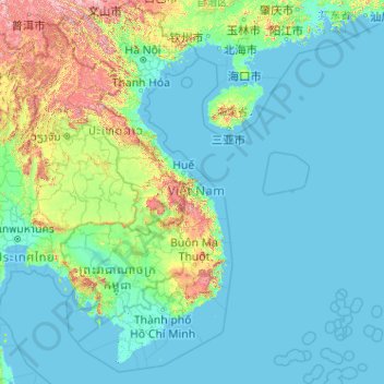
Name: Vietnam topographic map, elevation, terrain.
Location: Vietnam (7.69209 102.14386 23.39269 114.85726)
Average elevation: 173 m
Minimum elevation: -3 m
Maximum elevation: 2,808 m
Due to differences in latitude and the marked variety in topographical relief, Vietnam's climate tends to vary considerably for each region. Vietnam is a country located in the tropics, however Northern Vietnam, including Hanoi, is considered a subtropical region by Köppen climate classification and has times to be influenced by cold waves from the Northeast. Cold waves also can influence northern part of Central Vietnam. During the winter or dry season, extending roughly from November to April, the monsoon winds usually blow from the northeast along the Chinese coast and across the Gulf of Tonkin, picking up considerable moisture. The average annual temperature is generally higher in the plains than in the mountains, especially in southern Vietnam compared to the north. Temperatures vary less in the southern plains around Ho Chi Minh City and the Mekong Delta, ranging from between 21 and 35 °C (69.8 and 95.0 °F) over the year. In Hanoi and the surrounding areas of Red River Delta, the temperatures are much lower between 15 and 33 °C (59.0 and 91.4 °F). Seasonal variations in the mountains, plateaus, and the northernmost areas are much more dramatic, with temperatures varying from 3 °C (37.4 °F) in December and January to 37 °C (98.6 °F) in July and August. During winter, snow occasionally falls over the highest peaks of the far northern mountains near the Chinese border. Vietnam receives high rates of precipitation in the form of rainfall with an average amount from 1,500 mm (59 in) to 2,000 mm (79 in) during the monsoon seasons; this often causes flooding, especially in the cities with poor drainage systems. The country is also affected by tropical depressions, tropical storms and typhoons. Vietnam is one of the most vulnerable countries to climate change, with 55% of its population living in low-elevation coastal areas.
Other topographic maps
Click on a map to view its topography, its elevation and its terrain.
Conroe
United States > Texas > Montgomery County
Conroe, Montgomery County, Texas, United States
Average elevation: 62 m
Qatar
Qatar
Average elevation: 20 m
Weerawila
Weerawila, Hambantota District, Southern Province, 82632, Sri Lanka
Average elevation: 30 m
Bokkawala
Bokkawala, Kandy District, Central Province, Sri Lanka
Average elevation: 489 m
Medawala
Medawala, Kandy District, Central Province, Sri Lanka
Average elevation: 510 m
Macdonnell Region
Macdonnell Region, Northern Territory, 0872, Australia
Average elevation: 390 m
Barcelona
Spain > Catalonia > Barcelonès
Barcelona, Barcelonès, Barcelona, Catalonia, 08001, Spain
Average elevation: 65 m
Saudi Arabia
Saudi Arabia
Average elevation: 551 m
Nantwich
United Kingdom > England > Cheshire East
Nantwich, Cheshire East, England, United Kingdom
Average elevation: 45 m
Wattegama
Wattegama, Kandy District, Central Province, 20810, Sri Lanka
Average elevation: 631 m
Baduraliya
Sri Lanka > Western Province > Palinda-Nuwara (Baduraliya) DS Division
Baduraliya, Palinda-Nuwara (Baduraliya) DS Division, Kalutara District, Western Province, Sri Lanka
Average elevation: 67 m
Kattiya Junction
Sri Lanka > Western Province > Delkanda
Kattiya Junction, Delkanda, Colombo District, Western Province, 10250, Sri Lanka
Average elevation: 15 m
Imbituba
Imbituba, Região Geográfica Imediata de Florianópolis, Região Geográfica Intermediária de Florianópolis, Santa Catarina, South Region, 88780-000, Brazil
Average elevation: 26 m
Sahara
Algeria > Tamanrasset > Tazrouk District > Tazrouk
Sahara, Tazrouk, Tazrouk District, Tamanrasset, Algeria
Average elevation: 650 m
Mount Tabor
United States > Vermont > Rutland County
Mount Tabor, Rutland County, Vermont, United States
Average elevation: 548 m
Ambanpola
Sri Lanka > North Western Province
Ambanpola, Kurunegala District, North Western Province, Sri Lanka
Average elevation: 85 m
Nikaweratiya
Sri Lanka > North Western Province
Nikaweratiya, Kurunegala District, North Western Province, 60470, Sri Lanka
Average elevation: 49 m
Wewala
Wewala, Colombo District, Western Province, 10300, Sri Lanka
Average elevation: 11 m
Pallepitiya
Sri Lanka > Central Province > Kurunduwatte
Pallepitiya, Kurunduwatte, Kandy District, Central Province, 20500, Sri Lanka
Average elevation: 747 m
Poththapitiya
Poththapitiya, Kandy District, Central Province, 20300, Sri Lanka
Average elevation: 544 m
Wattegama
Wattegama, Monaragala District, Uva Province, Sri Lanka
Average elevation: 89 m
Perakumpura
Sri Lanka > Uva Province > Ethimale
Perakumpura, Ethimale, Monaragala District, Uva Province, Sri Lanka
Average elevation: 81 m
Walahena
Walahena, Kandy District, Central Province, 20850, Sri Lanka
Average elevation: 580 m
Bulathsinhala
Sri Lanka > Western Province > Bulathsinhala DS Division
Bulathsinhala, Bulathsinhala DS Division, Kalutara District, Western Province, 12300, Sri Lanka
Average elevation: 53 m
Horana
Sri Lanka > Western Province > Horana DS Division
Horana, Horana DS Division, Kalutara District, Western Province, Sri Lanka
Average elevation: 37 m
Ambalantota
Ambalantota, Hambantota District, Southern Province, 82100, Sri Lanka
Average elevation: 7 m
Bandagiriya Tank bund2
Bandagiriya Tank bund2, Hambantota District, Southern Province, Sri Lanka
Average elevation: 26 m
Yodha Kandiya
Yodha Kandiya, Hambantota District, Southern Province, 82600, Sri Lanka
Average elevation: 17 m
Parangiyawadiya Wewa Distribution Canal
Sri Lanka > North Central Province
Parangiyawadiya Wewa Distribution Canal, Anuradhapura District, North Central Province, Sri Lanka
Average elevation: 71 m
Ranorawa
Sri Lanka > North Central Province
Ranorawa, Anuradhapura District, North Central Province, Sri Lanka
Average elevation: 80 m
Palugaswewa
Sri Lanka > North Central Province
Palugaswewa, Anuradhapura District, North Central Province, 50150, Sri Lanka
Average elevation: 168 m
Ikirigollewa
Sri Lanka > North Central Province
Ikirigollewa, Anuradhapura District, North Central Province, 50450, Sri Lanka
Average elevation: 86 m
Central Ethiopia Regional State
Central Ethiopia Regional State, Ethiopia
Average elevation: 1,975 m
Allexton
United Kingdom > England > Leicestershire > Harborough
Allexton, Harborough, Leicestershire, England, LE15 9AG, United Kingdom
Average elevation: 128 m
Galilee
United States > New Jersey > Monmouth County > Monmouth Beach
Galilee, Monmouth Beach, Monmouth County, New Jersey, 07750, United States
Average elevation: 1 m
Mount Nebo
Jordan > Madaba > Faisaliah Sub-District
Mount Nebo, Faisaliah Sub-District, Madaba Qasabah District, Madaba, Jordan
Average elevation: 533 m
Mount of Beatitudes
Israel > North District > Emek HaYarden Regional Council
Mount of Beatitudes, Emek HaYarden Regional Council, Kinneret Subdistrict, North District, Israel
Average elevation: -128 m
Mount Ararat
Mount Ararat, Iğdır Merkez, Iğdır, Eastern Anatolia Region, Turkey
Average elevation: 4,582 m
Daulagala
Daulagala, Kandy District, Central Province, 20620, Sri Lanka
Average elevation: 549 m
Galagedara
Galagedara, Kandy District, Central Province, Sri Lanka
Average elevation: 395 m
Yatiwawala
Sri Lanka > Central Province > Katugasthota
Yatiwawala, Katugasthota, Kandy District, Central Province, 20250, Sri Lanka
Average elevation: 489 m
Millaniya
Sri Lanka > Western Province > Millaniya DS Division
Millaniya, Millaniya DS Division, Kalutara District, Western Province, 12412, Sri Lanka
Average elevation: 12 m