
Make a donation
Aargau topographic map
Click on the map to display elevation.
Make a donation
About this map
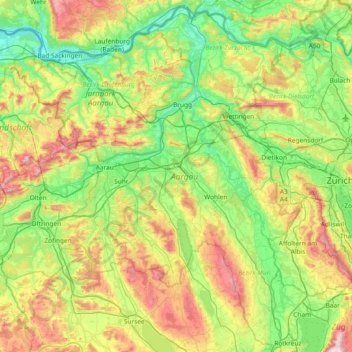
Name: Aargau topographic map, elevation, terrain.
Location: Aargau, Switzerland (47.13748 7.71347 47.62111 8.45510)
Average elevation: 509 m
Minimum elevation: 277 m
Maximum elevation: 1,017 m
Make a donation
Other topographic maps
Click on a map to view its topography, its elevation and its terrain.
Chlinismad
Switzerland > Bern > Thun administrative district > Forst-Längenbühl > Längenbühl
Average elevation: 638 m
Make a donation
Chironico
Switzerland > Ticino > Distretto di Leventina
The municipality is located in the Leventina district, on the right slope of the mid-Leventina valley at an elevation of 786 meters (2,579 ft). The municipality stretches from the Ticino river at the Biaschina-Schlucht (elevation 450 m (1,480 ft)) up to the Pizzo Campo Tencia (3,072 m (10,079 ft)) in the upper…
Average elevation: 1,026 m
Make a donation
Murris
Switzerland > St. Gallen > Wahlkreis Werdenberg > Wartau > Weite-Wartau
Average elevation: 550 m
Make a donation
Les Avants
Switzerland > Vaud > District de la Riviera-Pays-d’Enhaut > Montreux
Average elevation: 1,111 m
Make a donation
Bodio TI
Switzerland > Ticino > Distretto di Leventina
The municipality is located in the Leventina district, at an elevation of 321 m (1,053 ft) on the left side of the lower Leventina valley.
Average elevation: 875 m
Make a donation
Gstaad
Switzerland > Bern > Obersimmental-Saanen administrative district
Long known for its walking and hiking trails of varying degrees of difficulty, the mountain air and ambiance attract guests year-round from around the world. Gstaad is also known for its ski and cross-country slopes and winter hiking trails. Glacier 3000 is a major attraction, offering guaranteed snow from…
Average elevation: 1,245 m
Make a donation
Furi
Switzerland > Wallis > Visp > Zermatt
Furi is an alpine hamlet in the Pennine Alps, located three kilometers south of Zermatt, Switzerland at an altitude of 1,687m. It is located on a relatively flat area of land between the Gornera and Zmuttbach rivers.
Average elevation: 2,206 m
Make a donation
Make a donation
Männlichen
Switzerland > Bern > Interlaken-Oberhasli administrative district > Grindelwald
Average elevation: 1,709 m
Make a donation
Make a donation
Eiger
Switzerland > Bern > Interlaken-Oberhasli administrative district > Grindelwald
Average elevation: 2,944 m
Hockenhorn
Switzerland > Bern > Frutigen-Niedersimmental administrative district > Kandersteg
Average elevation: 2,599 m
Hockenhorn
Switzerland > Bern > Frutigen-Niedersimmental administrative district > Kandersteg
Average elevation: 2,599 m
Make a donation
Eau-Rouge
Switzerland > Wallis > Entremont > Chamoille (Sembrancher) > Les Champmanins
Average elevation: 1,034 m
Make a donation
Make a donation
Make a donation
Haldenstein
Switzerland > Grisons > Plessur > Chur
Before 2017, the municipality was located in the Fünf Dörfer sub-district of the Landquart district, after 2017 it was part of the Plessur Region. It is located north of Chur and on the left bank of the Rhine River. It consists of the haufendorf (an irregular, unplanned and quite closely packed village,…
Average elevation: 826 m
Make a donation
Make a donation
Les Briesses
Switzerland > Wallis > Sierre > Crans-Montana > Chermignon-d'en-Bas
Average elevation: 1,179 m
Make a donation
Horeweid
Switzerland > Bern > Interlaken-Oberhasli administrative district > Därligen
Average elevation: 1,162 m
Make a donation
Dents du Midi
Switzerland > Wallis > Monthey > Val-d'Illiez
The Dents du Midi are situated on the border between the communes of Val-d'Illiez and Evionnaz. The north face rises above the Val d'Illiez while the south face overlooks the Lac de Salanfe, an artificial reservoir. The ridge of the chain is situated at an altitude varying between 2,997 and 3,258 meters (9,833…
Average elevation: 2,440 m
Make a donation
Make a donation
Make a donation
Chironico
Switzerland > Ticino > Distretto di Leventina
The municipality is located in the Leventina district, on the right slope of the mid-Leventina valley at an elevation of 786 meters (2,579 ft). The municipality stretches from the Ticino river at the Biaschina-Schlucht (elevation 450 m (1,480 ft)) up to the Pizzo Campo Tencia (3,072 m (10,079 ft)) in the upper…
Average elevation: 1,026 m
Make a donation
Make a donation
Mase
Switzerland > Wallis > Hérens > Mont-Noble
The village is located in the Hérens district on the right bank of the Borgne and the left bank of the Rhone in the Val d'Hérens at an elevation of 1,345 m (4,413 ft). It consists of the village of Mase.
Average elevation: 1,272 m
Lac Vert
Switzerland > Wallis > Monthey > Val-d'Illiez
Lake Vert is a lake in the Chablais region of the canton of Valais, Switzerland. The lake is located in the municipality of Val-d'Illiez, at an elevation of 1972 metres, near the border with France. Lac de Chésery lies 600 metres north.
Average elevation: 1,932 m
Make a donation
Make a donation