
Southern Province topographic map
Interactive map
Click on the map to display elevation.
About this map
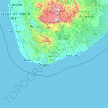
Name: Southern Province topographic map, elevation, terrain.
Location: Southern Province, Sri Lanka (5.71900 79.79310 6.57801 81.86764)
Average elevation: 136 m
Minimum elevation: -1 m
Maximum elevation: 2,453 m
Other topographic maps
Click on a map to view its topography, its elevation and its terrain.
Baduraliya
Sri Lanka > Western Province > Palinda-Nuwara (Baduraliya) DS Division
Baduraliya (Sinhala: බදුරලිය) is a town in the Kalutara District in Sri Lanka. It is approximately 82 km (51 mi) from Colombo and 58 km (36 mi) from Rathnapura. Baduraliya was named after a rally against taxes. "Badu" in Sinhala means taxes and “raliya” means a rally. Baduraliya is surrounded…
Average elevation: 67 m
Kandy
Sri Lanka > Central Province > Kandy
Kandy is located in the mountainous and thickly forested interior of the island. The city is located in between multiple mountain ranges including the Knuckles mountain range and the Hanthana Mountain Range, giving the city an elevation of 500 metres (1,600 ft) above sea level. It lies adjacent to the…
Average elevation: 621 m
Sri Jayawardenepura Kotte
Sri Lanka > Western Province > Sri Jayawardenepura Kotte
Average elevation: 12 m