
Bulgaria topographic map
Interactive map
Click on the map to display elevation.
Bulgaria
Bulgaria is a small country situated in Southeastern Europe, in the east of the Balkans. Its territory covers an area of 110,994 square kilometres (42,855 sq mi), while land borders with its five neighbouring countries run a total length of 1,808 kilometres (1,123 mi), and its coastline is 354 kilometres (220 mi) long. Bulgaria's geographic coordinates are 43° N 25° E. The most notable topographical features of the country are the Danubian Plain, the Balkan Mountains, the Thracian Plain, and the Rila-Rhodope massif. The southern edge of the Danubian Plain slopes upward into the foothills of the Balkans, while the Danube defines the border with Romania. The Thracian Plain is roughly triangular, beginning southeast of Sofia and broadening as it reaches the Black Sea coast.
About this map
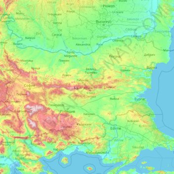
Name: Bulgaria topographic map, elevation, terrain.
Location: Bulgaria (41.23537 22.35715 44.21622 28.88754)
Average elevation: 300 m
Minimum elevation: -3 m
Maximum elevation: 2,750 m
Other topographic maps
Click on a map to view its topography, its elevation and its terrain.
Monviso
Italy > Piedmont > Cuneo > Pontechianale
Monte Viso is the location of a Neolithic jadeite quarry, at an elevation of 2,000 to 2,400 metres. Its productivity peaked around 5000 BC. The jadeite was used to make cult axes, which are found all over western Europe. One such ceremonial axe head was found as far away as a small hill called Tristia in…
Average elevation: 2,985 m
Ongole
India > Andhra Pradesh > Ongole
Ongole is located at 15.5°N 80.05°E. It has an average elevation of 10 m (33 ft) AMSL and is situated on the plains. The city is around 149 kilometres (93 mi) to the south west of Amaravati, the stat capital.
Average elevation: 15 m
Murree
Pakistan > Punjab > Murree District
Murree is a mountain resort city in the northernmost region of the Punjab province of Pakistan. Lying in the Galyat region of the Pir Panjal Range under the western Himalayas, it is located on the outskirts of the Islamabad–Rawalpindi metropolitan area. The town was built in the mid 19th-century and it…
Average elevation: 1,718 m
Hemu River
China > Xinjiang > Burqin County > Kom-Kanas Mongolian Ethnic Township
Average elevation: 1,732 m
Abbottabad
Pakistan > Khyber Pakhtunkhwa > Abbottābād District
Abbottabad is a city in the Hazara Division of Khyber Pakhtunkhwa province, Pakistan. It is the 40th largest city in the country and 6th largest in the province by population, and serves as the headquarter of its namesake tehsil and district. It is about 120 km (75 mi) north of Islamabad-Rawalpindi and 150 km…
Average elevation: 1,363 m
Argalasti
Greece > Thessaly and Central Greece > Regional Unit of Magnesia > Municipal unit of Argalasti
Average elevation: 226 m
Doha
Doha is located on the central-east portion of Qatar, bordered by the Persian Gulf on its coast. Its elevation is 10 m (33 ft). Doha is highly urbanized. Land reclamation off the coast has added 400 hectares of land and 30 km of coastline. Half of the 22 km² of surface area which Hamad International Airport…
Average elevation: 12 m
Mount Wudang
China > Hubei > Danjiangkou City
Modern maps show the elevation of the highest of the peaks in the Wudang Shan "proper" as 1612 meters; however, the entire Wudangshan range has somewhat higher elevations elsewhere.
Average elevation: 1,172 m
Les Rieux Vieux
France > Nouvelle-Aquitaine > Haute-Vienne > Saint-Pardoux-le-Lac
Average elevation: 380 m
Dingle
On March 8, 1820, with the support of 31 cabezas de barangay of the principalía or the hispanized Christian descendants of the pre-colonial datus of Dingle and certification of the parish priest of Laglag, Fray Juan Frayle, OSA (Dingle cura párroco, 1829–1849), a petition for the re-elevation of Dingle…
Average elevation: 49 m
Pico Duarte
Dominican Republic > Santiago > San José de las Matas
Pico Duarte is the highest peak in the Dominican Republic, on the island of Hispaniola and in all the Caribbean. At 3,101 m (10,174 ft) above sea level, it gives Hispaniola the 16th-highest maximum elevation of any island in the world. Additionally, it is only 85 kilometres (53 miles) northeast of the region's…
Average elevation: 2,750 m
Jijiga
Jijiga (Somali: Jigjiga, Amharic: ጅጅጋ, Jijiga) is the capital city of Somali Region, Ethiopia. It became the capital of the Somali Region in 1995 after it was moved from Gode. Located in the Fafan Zone with 75 km (37 mi) west of the border with Somaliland, the city has an elevation of 1,634 metres above…
Average elevation: 1,732 m
Phum Trapeang Svay
Cambodia > Phnom Penh > Khan Sen Sok > Sangkat Kouk Khleang
Average elevation: 11 m
Zona Central
Chile > Maule Region > Provincia de Curicó > Teno
The topography of central Chile includes a coastal range of mountains running parallel to the Andes. Lying between the two mountain ranges is the so-called Central Valley, which contains some of the richest agricultural land in the country, especially in its northern portion. The area just north and south of…
Average elevation: 1,121 m
Ascott
United Kingdom > England > Warwickshire > Stratford-on-Avon > Whichford
Average elevation: 160 m
Jiaming Lake
Taiwan > Taitung County > Haiduan
This oval-shaped lake is located along the Southern Cross-Island Highway. The lake surface is 120 meters long and 80 meters wide at an elevation of 3,310 meters. It is surrounded by emerald green forest plantation and wildlife. The area surrounds the lake has lodges and hiking trail with a length of 13 km.
Average elevation: 3,191 m
Windhoek
Windhoek has over 300 sunny days per year. It experiences a hot semi-arid climate (BSh) according to Köppen climate classification as the annual average temperature is above 18 °C (64 °F). The temperature throughout the year would be called mild, due to altitude influence. The annual average high and low…
Average elevation: 1,679 m