
Nepal topographic map
Interactive map
Click on the map to display elevation.
About this map
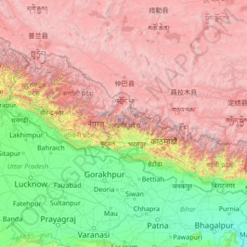
Name: Nepal topographic map, elevation, terrain.
Location: Nepal (26.34776 80.05708 30.47149 88.20153)
Average elevation: 2,612 m
Minimum elevation: 21 m
Maximum elevation: 8,152 m
Nepal is divided into three principal physiographic belts known as Himal–Pahad–Terai. Himal is the mountain region containing snow and situated in the Great Himalayan Range; it makes up the northern part of Nepal. It contains the highest elevations in the world including 8,848.86 metres (29,032 ft) height Mount Everest (Sagarmāthā in Nepali) on the border with China. Seven other of the world's "eight-thousanders" are in Nepal or on its border with Tibet: Lhotse, Makalu, Cho Oyu, Kangchenjunga, Dhaulagiri, Annapurna and Manaslu. Pahad is the mountain region that does not generally contain snow. The mountains vary from 800 to 4,000 metres (2,600 to 13,100 ft) in altitude, with progression from subtropical climates below 1,200 metres (3,900 ft) to alpine climates above 3,600 metres (11,800 ft). The Lower Himalayan Range, reaching 1,500 to 3,000 metres (4,900 to 9,800 ft), is the southern limit of this region, with subtropical river valleys and "hills" alternating to the north of this range. Population density is high in valleys but notably less above 2,000 metres (6,600 ft) and very low above 2,500 metres (8,200 ft), where snow occasionally falls in winter. The southern lowland plains or Terai bordering India are part of the northern rim of the Indo-Gangetic Plain. Terai is the lowland region containing some hill ranges. The plains were formed and are fed by three major Himalayan rivers: the Koshi, the Narayani, and the Karnali as well as smaller rivers rising below the permanent snowline. This region has a subtropical to tropical climate. The outermost range of the foothills called Sivalik Hills or Churia Range, cresting at 700 to 1,000 metres (2,300 to 3,280 ft), marks the limits of the Gangetic Plain. Broad, low valleys called Inner Terai Valleys (Bhitri Tarai Upatyaka) lie north of these foothills in several places.
Other topographic maps
Click on a map to view its topography, its elevation and its terrain.
Barcelona
Spain > Catalonia > Barcelonès
Barcelona, Barcelonès, Barcelona, Catalonia, 08001, Spain
Average elevation: 65 m
Klein Haasdal
Netherlands > Limburg > Schimmert
Klein Haasdal, Schimmert, Beekdaelen, Limburg, Netherlands, 6333 DZ, Netherlands
Average elevation: 126 m
Qatar
Qatar
Average elevation: 20 m
Pulau Hantu Kecil
Pulau Hantu Kecil, Western Islands, Southwest, Singapore
Average elevation: 2 m
Saint-Georges-des-Gardes
France > Pays de la Loire > Maine-et-Loire > Chemillé-en-Anjou
Saint-Georges-des-Gardes, Chemillé-en-Anjou, Cholet, Maine-et-Loire, Pays de la Loire, Metropolitan France, 49120, France
Average elevation: 122 m
Argentonnay
France > Nouvelle-Aquitaine > Deux-Sèvres
Argentonnay, Bressuire, Deux-Sèvres, Nouvelle-Aquitaine, Metropolitan France, 79150, France
Average elevation: 121 m
Les Gardes
France > Auvergne-Rhône-Alpes > Cantal > Saint-Jacques-des-Blats
Les Gardes, Saint-Jacques-des-Blats, Aurillac, Cantal, Auvergne-Rhône-Alpes, Metropolitan France, 15800, France
Average elevation: 1,266 m
Perakumpura
Sri Lanka > Uva Province > Ethimale
Perakumpura, Ethimale, Monaragala District, Uva Province, Sri Lanka
Average elevation: 81 m
Horana
Sri Lanka > Western Province > Horana DS Division
Horana, Horana DS Division, Kalutara District, Western Province, Sri Lanka
Average elevation: 37 m
Central Ethiopia Regional State
Central Ethiopia Regional State, Ethiopia
Average elevation: 1,975 m
Goldthwaite
United States > Texas > Mills County
Goldthwaite, Mills County, Texas, 76844, United States
Average elevation: 485 m
Conroe
United States > Texas > Montgomery County
Conroe, Montgomery County, Texas, United States
Average elevation: 62 m
Macdonnell Region
Macdonnell Region, Northern Territory, 0872, Australia
Average elevation: 390 m
Wattegama
Wattegama, Kandy District, Central Province, 20810, Sri Lanka
Average elevation: 631 m
Medawala
Medawala, Kandy District, Central Province, Sri Lanka
Average elevation: 510 m
Millaniya
Sri Lanka > Western Province > Millaniya DS Division
Millaniya, Millaniya DS Division, Kalutara District, Western Province, 12412, Sri Lanka
Average elevation: 12 m
Nantwich
United Kingdom > England > Cheshire East
Nantwich, Cheshire East, England, United Kingdom
Average elevation: 45 m
Ambanpola
Sri Lanka > North Western Province
Ambanpola, Kurunegala District, North Western Province, Sri Lanka
Average elevation: 85 m
Bokkawala
Bokkawala, Kandy District, Central Province, Sri Lanka
Average elevation: 489 m
Bulathsinhala
Sri Lanka > Western Province > Bulathsinhala DS Division
Bulathsinhala, Bulathsinhala DS Division, Kalutara District, Western Province, 12300, Sri Lanka
Average elevation: 53 m
Baduraliya
Sri Lanka > Western Province > Palinda-Nuwara (Baduraliya) DS Division
Baduraliya, Palinda-Nuwara (Baduraliya) DS Division, Kalutara District, Western Province, Sri Lanka
Average elevation: 67 m
Kattiya Junction
Sri Lanka > Western Province > Delkanda
Kattiya Junction, Delkanda, Colombo District, Western Province, 10250, Sri Lanka
Average elevation: 15 m
Bandagiriya Tank bund2
Bandagiriya Tank bund2, Hambantota District, Southern Province, Sri Lanka
Average elevation: 26 m
Yodha Kandiya
Yodha Kandiya, Hambantota District, Southern Province, 82600, Sri Lanka
Average elevation: 17 m
Weerawila
Weerawila, Hambantota District, Southern Province, 82632, Sri Lanka
Average elevation: 30 m
Saudi Arabia
Saudi Arabia
Average elevation: 551 m
Mount Tabor
United States > Vermont > Rutland County
Mount Tabor, Rutland County, Vermont, United States
Average elevation: 548 m
Poththapitiya
Poththapitiya, Kandy District, Central Province, 20300, Sri Lanka
Average elevation: 544 m
Walahena
Walahena, Kandy District, Central Province, 20850, Sri Lanka
Average elevation: 580 m
Ranorawa
Sri Lanka > North Central Province
Ranorawa, Anuradhapura District, North Central Province, Sri Lanka
Average elevation: 80 m
Palugaswewa
Sri Lanka > North Central Province
Palugaswewa, Anuradhapura District, North Central Province, 50150, Sri Lanka
Average elevation: 168 m
Ikirigollewa
Sri Lanka > North Central Province
Ikirigollewa, Anuradhapura District, North Central Province, 50450, Sri Lanka
Average elevation: 86 m
Imbituba
Imbituba, Região Geográfica Imediata de Florianópolis, Região Geográfica Intermediária de Florianópolis, Santa Catarina, South Region, 88780-000, Brazil
Average elevation: 26 m
Sahara
Algeria > Tamanrasset > Tazrouk District > Tazrouk
Sahara, Tazrouk, Tazrouk District, Tamanrasset, Algeria
Average elevation: 650 m
Mount Ararat
Mount Ararat, Iğdır Merkez, Iğdır, Eastern Anatolia Region, Turkey
Average elevation: 4,582 m
Nikaweratiya
Sri Lanka > North Western Province
Nikaweratiya, Kurunegala District, North Western Province, 60470, Sri Lanka
Average elevation: 49 m
Wewala
Wewala, Colombo District, Western Province, 10300, Sri Lanka
Average elevation: 11 m
Pallepitiya
Sri Lanka > Central Province > Kurunduwatte
Pallepitiya, Kurunduwatte, Kandy District, Central Province, 20500, Sri Lanka
Average elevation: 747 m
Wattegama
Wattegama, Monaragala District, Uva Province, Sri Lanka
Average elevation: 89 m
Ambalantota
Ambalantota, Hambantota District, Southern Province, 82100, Sri Lanka
Average elevation: 7 m