
Bắc Giang Province topographic map
Interactive map
Click on the map to display elevation.
About this map
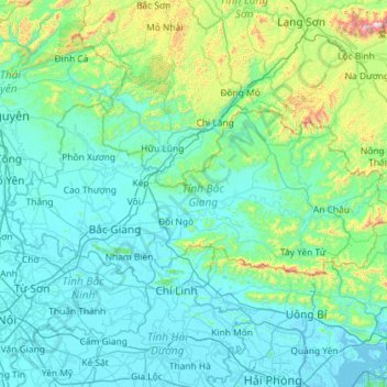
Name: Bắc Giang Province topographic map, elevation, terrain.
Location: Bắc Giang Province, Vietnam (21.12195 105.88058 21.62627 107.03347)
Average elevation: 153 m
Minimum elevation: -3 m
Maximum elevation: 1,461 m
The terrain is moderately mountainous, lying between the high mountains to the north and the Red River Delta to the south. Although a large part of the terrain is mountainous most of it is not isolated. The region to the northern end of the province is mountainous uncleared forest. To the east and southeast of the province is Đông Triều and Mount Yên Tử, located within the Yên Tử Nature Reserve. The elevation of the province is mostly in the 300–900 metres (980–2,950 ft) range, with a maximum of 1,068 metres (3,504 ft) (Mount Yên Tử). To the northeastern end of the province, along the border with Quảng Ninh there is the Khe Rỗ forest, spanning 71.53 km2, with a rich biodiversity.
Other topographic maps
Click on a map to view its topography, its elevation and its terrain.
Hồ Sông Quao
Vietnam > Binh Thuan province > Hàm Thuận Bắc District > Xã Hàm Trí
Hồ Sông Quao, Xã Hàm Trí, Hàm Thuận Bắc District, Bình Thuận Province, Vietnam
Average elevation: 126 m
Xã Mương Mán
Vietnam > Binh Thuan province > Hàm Thuận Nam District
Xã Mương Mán, Hàm Thuận Nam District, Bình Thuận Province, Vietnam
Average elevation: 32 m
Long beach
Vietnam > Kien Giang Province > Phú Quốc > Xã Dương Tơ
Long beach, Phường An Thới, Xã Dương Tơ, Phú Quốc, Kiên Giang Province, Vietnam
Average elevation: 17 m
Cư M'gar District
Cư M'gar District, Đắk Lắk Province, Vietnam
Average elevation: 470 m
Thạch Hà District
Thạch Hà District, Hà Tĩnh Province, Vietnam
Average elevation: 36 m
Phường Trần Quang Diệu
Vietnam > Bình Định Province > Quy Nhơn
Phường Trần Quang Diệu, Quy Nhơn, Bình Định Province, Vietnam
Average elevation: 45 m
Định Quang
Vietnam > Bình Định Province > Vĩnh Thạnh District
Định Quang, Vĩnh Thạnh District, Bình Định Province, Vietnam
Average elevation: 70 m
Định Quán
Vietnam > Dong Nai province > Định Quán District
Định Quán, Định Quán District, Đồng Nai Province, Vietnam
Average elevation: 141 m
Cu Bi Commune
Vietnam > Bà Rịa - Vũng Tàu Province > Chau Duc District
Cu Bi Commune, Chau Duc District, Bà Rịa - Vũng Tàu Province, Vietnam
Average elevation: 135 m
Phặt Chỉ
Vietnam > Lạng Sơn Province > Lộc Bình District > Mẫu Sơn Commune
Phặt Chỉ, Mẫu Sơn Commune, Lộc Bình District, Lạng Sơn Province, Vietnam
Average elevation: 772 m
Mường Tè District
Mường Tè District, Lai Châu Province, Vietnam
Average elevation: 1,058 m
Cam Lâm
Vietnam > Nghe An province > Con Cuông District
Cam Lâm, Con Cuông District, Nghệ An Province, Vietnam
Average elevation: 101 m
Bình Hòa
Vietnam > An Giang province > Châu Thành District > Xã Bình Hòa
Bình Hòa, Xã Bình Hòa, Châu Thành District, An Giang Province, Vietnam
Average elevation: 3 m
Sa Pa
Vietnam > Lao Cai province > Sa Pa
Sa Pa, Lào Cai Province, 33000, Vietnam
Average elevation: 1,520 m
Vôi
Vietnam > Bắc Giang Province > Lạng Giang District
Vôi, Lạng Giang District, Bắc Giang Province, Vietnam
Average elevation: 15 m
Làng Giảng
Vietnam > Lai Chau province > Lai Châu
Làng Giảng, Sùng Phài Commune, Lai Châu, Lai Châu Province, Vietnam
Average elevation: 976 m
Du Già
Vietnam > Ha Giang province > Yên Minh District
Du Già, Yên Minh District, Hà Giang Province, 20318, Vietnam
Average elevation: 655 m
Van Long Wetland Nature Reserve
Vietnam > Ninh Binh province > Gia Viễn District > Vân Long
Van Long Wetland Nature Reserve, Vân Long, Gia Viễn District, Ninh Bình Province, Vietnam
Average elevation: 45 m
Dat Do Town
Vietnam > Bà Rịa - Vũng Tàu Province > Dat Do District
Dat Do Town, Dat Do District, Bà Rịa - Vũng Tàu Province, Vietnam
Average elevation: 16 m
Spratly Islands
Spratly Islands, Khánh Hòa Province, Vietnam
Average elevation: 0 m
Mai Châu District
Mai Châu District, Hoà Bình province, Vietnam
Average elevation: 549 m
Yên Thủy District
Yên Thủy District, Hoà Bình province, Vietnam
Average elevation: 125 m
Phong Nha Town
Vietnam > Quang Binh province > Bố Trạch District
Phong Nha Town, Bố Trạch District, Quảng Bình Province, Vietnam
Average elevation: 66 m
Kê Gà
Vietnam > Binh Thuan province > Hàm Thuận Nam District
Kê Gà, Hàm Thuận Nam District, Bình Thuận Province, Vietnam
Average elevation: 14 m
Con Cuông District
Con Cuông District, Nghệ An Province, Vietnam
Average elevation: 430 m
Mộ Đức District
Mộ Đức District, Quảng Ngãi Province, Vietnam
Average elevation: 35 m
Ngọc Lặc District
Ngọc Lặc District, Thanh Hoá Province, Vietnam
Average elevation: 104 m
Quỳnh Nhai District
Quỳnh Nhai District, Sơn La Province, Vietnam
Average elevation: 707 m
Hương Khê District
Hương Khê District, Hà Tĩnh Province, 46003, Vietnam
Average elevation: 262 m
Sesan 4
Vietnam > Kon Tum province > Ia H'Drai District > Xã Ia Tơi
Sesan 4, Xã Ia Tơi, Ia H'Drai District, Kon Tum Province, Vietnam
Average elevation: 196 m
Đăk Mil
Vietnam > Đăk Nông Province > Đắk Mil District
Đăk Mil, Đắk Mil District, Đăk Nông Province, Vietnam
Average elevation: 692 m
Xã Thanh Sơn
Vietnam > Dong Nai province > Định Quán District
Xã Thanh Sơn, Định Quán District, Đồng Nai Province, Vietnam
Average elevation: 125 m
Xã Phước Lâm
Vietnam > Long An Province > Can Giuoc District
Xã Phước Lâm, Can Giuoc District, Long An Province, Vietnam
Average elevation: 3 m
Xã Minh Thắng
Vietnam > Bình Phước Province > Chơn Thành Town
Xã Minh Thắng, Chơn Thành Town, Bình Phước Province, Vietnam
Average elevation: 59 m
Binh Thanh
Vietnam > Đồng Tháp Province > Lap Vo District
Binh Thanh, Lap Vo District, Đồng Tháp Province, Vietnam
Average elevation: 4 m
Triệu Sơn District
Triệu Sơn District, Thanh Hoá Province, Vietnam
Average elevation: 35 m
Đức Trọng District
Đức Trọng District, Lâm Đồng Province, 66000, Vietnam
Average elevation: 990 m