
Belarus topographic map
Interactive map
Click on the map to display elevation.
About this map
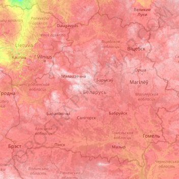
Name: Belarus topographic map, elevation, terrain.
Location: Belarus (51.26269 23.17833 56.17225 32.76278)
Average elevation: 153 m
Minimum elevation: 13 m
Maximum elevation: 328 m
The highest point is Dzyarzhynskaya Hara (Dzyarzhynsk Hill) at 345 metres (1,132 ft), and the lowest point is on the Neman River at 90 m (295 ft). The average elevation of Belarus is 160 m (525 ft) above sea level. The climate features mild to cold winters, with January minimum temperatures ranging from −4 °C (24.8 °F) in southwest (Brest) to −8 °C (17.6 °F) in northeast (Vitebsk), and cool and moist summers with an average temperature of 18 °C (64.4 °F). Belarus has an average annual rainfall of 550 to 700 mm (21.7 to 27.6 in). The country is in the transitional zone between continental climates and maritime climates.
Other topographic maps
Click on a map to view its topography, its elevation and its terrain.
Barcelona
Spain > Catalonia > Barcelonès
Barcelona, Barcelonès, Barcelona, Catalonia, 08001, Spain
Average elevation: 65 m
Klein Haasdal
Netherlands > Limburg > Schimmert
Klein Haasdal, Schimmert, Beekdaelen, Limburg, Netherlands, 6333 DZ, Netherlands
Average elevation: 126 m
Qatar
Qatar
Average elevation: 20 m
Pulau Hantu Kecil
Pulau Hantu Kecil, Western Islands, Southwest, Singapore
Average elevation: 2 m
Saint-Georges-des-Gardes
France > Pays de la Loire > Maine-et-Loire > Chemillé-en-Anjou
Saint-Georges-des-Gardes, Chemillé-en-Anjou, Cholet, Maine-et-Loire, Pays de la Loire, Metropolitan France, 49120, France
Average elevation: 122 m
Argentonnay
France > Nouvelle-Aquitaine > Deux-Sèvres
Argentonnay, Bressuire, Deux-Sèvres, Nouvelle-Aquitaine, Metropolitan France, 79150, France
Average elevation: 121 m
Les Gardes
France > Auvergne-Rhône-Alpes > Cantal > Saint-Jacques-des-Blats
Les Gardes, Saint-Jacques-des-Blats, Aurillac, Cantal, Auvergne-Rhône-Alpes, Metropolitan France, 15800, France
Average elevation: 1,266 m
Perakumpura
Sri Lanka > Uva Province > Ethimale
Perakumpura, Ethimale, Monaragala District, Uva Province, Sri Lanka
Average elevation: 81 m
Horana
Sri Lanka > Western Province > Horana DS Division
Horana, Horana DS Division, Kalutara District, Western Province, Sri Lanka
Average elevation: 37 m
Central Ethiopia Regional State
Central Ethiopia Regional State, Ethiopia
Average elevation: 1,975 m
Goldthwaite
United States > Texas > Mills County
Goldthwaite, Mills County, Texas, 76844, United States
Average elevation: 485 m
Conroe
United States > Texas > Montgomery County
Conroe, Montgomery County, Texas, United States
Average elevation: 62 m
Macdonnell Region
Macdonnell Region, Northern Territory, 0872, Australia
Average elevation: 390 m
Wattegama
Wattegama, Kandy District, Central Province, 20810, Sri Lanka
Average elevation: 631 m
Medawala
Medawala, Kandy District, Central Province, Sri Lanka
Average elevation: 510 m
Millaniya
Sri Lanka > Western Province > Millaniya DS Division
Millaniya, Millaniya DS Division, Kalutara District, Western Province, 12412, Sri Lanka
Average elevation: 12 m
Nantwich
United Kingdom > England > Cheshire East
Nantwich, Cheshire East, England, United Kingdom
Average elevation: 45 m
Ambanpola
Sri Lanka > North Western Province
Ambanpola, Kurunegala District, North Western Province, Sri Lanka
Average elevation: 85 m
Bokkawala
Bokkawala, Kandy District, Central Province, Sri Lanka
Average elevation: 489 m
Bulathsinhala
Sri Lanka > Western Province > Bulathsinhala DS Division
Bulathsinhala, Bulathsinhala DS Division, Kalutara District, Western Province, 12300, Sri Lanka
Average elevation: 53 m
Baduraliya
Sri Lanka > Western Province > Palinda-Nuwara (Baduraliya) DS Division
Baduraliya, Palinda-Nuwara (Baduraliya) DS Division, Kalutara District, Western Province, Sri Lanka
Average elevation: 67 m
Kattiya Junction
Sri Lanka > Western Province > Delkanda
Kattiya Junction, Delkanda, Colombo District, Western Province, 10250, Sri Lanka
Average elevation: 15 m
Bandagiriya Tank bund2
Bandagiriya Tank bund2, Hambantota District, Southern Province, Sri Lanka
Average elevation: 26 m
Yodha Kandiya
Yodha Kandiya, Hambantota District, Southern Province, 82600, Sri Lanka
Average elevation: 17 m
Weerawila
Weerawila, Hambantota District, Southern Province, 82632, Sri Lanka
Average elevation: 30 m
Saudi Arabia
Saudi Arabia
Average elevation: 551 m
Mount Tabor
United States > Vermont > Rutland County
Mount Tabor, Rutland County, Vermont, United States
Average elevation: 548 m
Poththapitiya
Poththapitiya, Kandy District, Central Province, 20300, Sri Lanka
Average elevation: 544 m
Walahena
Walahena, Kandy District, Central Province, 20850, Sri Lanka
Average elevation: 580 m
Ranorawa
Sri Lanka > North Central Province
Ranorawa, Anuradhapura District, North Central Province, Sri Lanka
Average elevation: 80 m
Palugaswewa
Sri Lanka > North Central Province
Palugaswewa, Anuradhapura District, North Central Province, 50150, Sri Lanka
Average elevation: 168 m
Ikirigollewa
Sri Lanka > North Central Province
Ikirigollewa, Anuradhapura District, North Central Province, 50450, Sri Lanka
Average elevation: 86 m
Imbituba
Imbituba, Região Geográfica Imediata de Florianópolis, Região Geográfica Intermediária de Florianópolis, Santa Catarina, South Region, 88780-000, Brazil
Average elevation: 26 m
Sahara
Algeria > Tamanrasset > Tazrouk District > Tazrouk
Sahara, Tazrouk, Tazrouk District, Tamanrasset, Algeria
Average elevation: 650 m
Mount Ararat
Mount Ararat, Iğdır Merkez, Iğdır, Eastern Anatolia Region, Turkey
Average elevation: 4,582 m
Nikaweratiya
Sri Lanka > North Western Province
Nikaweratiya, Kurunegala District, North Western Province, 60470, Sri Lanka
Average elevation: 49 m
Wewala
Wewala, Colombo District, Western Province, 10300, Sri Lanka
Average elevation: 11 m
Pallepitiya
Sri Lanka > Central Province > Kurunduwatte
Pallepitiya, Kurunduwatte, Kandy District, Central Province, 20500, Sri Lanka
Average elevation: 747 m
Wattegama
Wattegama, Monaragala District, Uva Province, Sri Lanka
Average elevation: 89 m
Ambalantota
Ambalantota, Hambantota District, Southern Province, 82100, Sri Lanka
Average elevation: 7 m