
Somalia topographic map
Interactive map
Click on the map to display elevation.
About this map
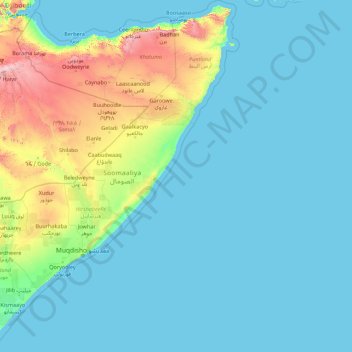
Name: Somalia topographic map, elevation, terrain.
Location: Somalia (-1.80320 40.98918 12.18891 51.61777)
Average elevation: 187 m
Minimum elevation: -1 m
Maximum elevation: 2,851 m
Cal Madow is a mountain range in the northeastern part of the country. Extending from several kilometres west of the city of Bosaso to the northwest of Erigavo, it features Somalia's highest peak, Shimbiris, which sits at an elevation of about 2,416 metres (7,927 ft). The rugged east–west ranges of the Karkaar Mountains also lie to the interior of the Gulf of Aden littoral. In the central regions, the country's northern mountain ranges give way to shallow plateaus and typically dry watercourses that are referred to locally as the Ogo. The Ogo's western plateau, in turn, gradually merges into the Haud, an important grazing area for livestock.
Other topographic maps
Click on a map to view its topography, its elevation and its terrain.
Barcelona
Spain > Catalonia > Barcelonès
Barcelona, Barcelonès, Barcelona, Catalonia, 08001, Spain
Average elevation: 65 m
Qatar
Qatar
Average elevation: 20 m
Compassvale Ancilla Park
Singapore > Northeast > Singapore
Compassvale Ancilla Park, Compassvale, Seng Kang, Singapore, Northeast, Singapore
Average elevation: 17 m
Nanxin
Taiwan > Chiayi County > Taibao City
Nanxin, Nanxin Village, Taibao City, Chiayi County, 612, Taiwan
Average elevation: 22 m
Makhado Local Municipality
South Africa > Limpopo > Vhembe District Municipality
Makhado Local Municipality, Vhembe District Municipality, Limpopo, South Africa
Average elevation: 846 m
Blouberg Local Municipality
South Africa > Limpopo > Capricorn District Municipality
Blouberg Local Municipality, Capricorn District Municipality, Limpopo, South Africa
Average elevation: 887 m
Blengi
Italy > Piedmont > Alessandria > Cerrina Monferrato
Blengi, Cerrina Monferrato, Alessandria, Piedmont, 15020, Italy
Average elevation: 229 m
Vigoleno
Italy > Emilia-Romagna > Piacenza
Vigoleno, Vernasca, Piacenza, Emilia-Romagna, Italy
Average elevation: 263 m
Macdonnell Region
Macdonnell Region, Northern Territory, 0872, Australia
Average elevation: 390 m
Argentonnay
France > Nouvelle-Aquitaine > Deux-Sèvres
Argentonnay, Bressuire, Deux-Sèvres, Nouvelle-Aquitaine, Metropolitan France, 79150, France
Average elevation: 121 m
Wattegama
Wattegama, Kandy District, Central Province, 20810, Sri Lanka
Average elevation: 631 m
Saint Isidore
Canada > Ontario > Prescott and Russell Counties > The Nation
Saint Isidore, The Nation, Prescott and Russell Counties, Eastern Ontario, Ontario, K0C 2B0, Canada
Average elevation: 63 m
Saudi Arabia
Saudi Arabia
Average elevation: 551 m
Klein Haasdal
Netherlands > Limburg > Schimmert
Klein Haasdal, Schimmert, Beekdaelen, Limburg, Netherlands, 6333 DZ, Netherlands
Average elevation: 126 m
Pulau Hantu Kecil
Pulau Hantu Kecil, Western Islands, Southwest, Singapore
Average elevation: 2 m
Mount Tabor
United States > Vermont > Rutland County
Mount Tabor, Rutland County, Vermont, United States
Average elevation: 548 m
Perakumpura
Sri Lanka > Uva Province > Ethimale
Perakumpura, Ethimale, Monaragala District, Uva Province, Sri Lanka
Average elevation: 81 m
Baduraliya
Sri Lanka > Western Province > Palinda-Nuwara (Baduraliya) DS Division
Baduraliya, Palinda-Nuwara (Baduraliya) DS Division, Kalutara District, Western Province, Sri Lanka
Average elevation: 67 m
Goldthwaite
United States > Texas > Mills County
Goldthwaite, Mills County, Texas, 76844, United States
Average elevation: 485 m
Saint-Georges-des-Gardes
France > Pays de la Loire > Maine-et-Loire > Chemillé-en-Anjou
Saint-Georges-des-Gardes, Chemillé-en-Anjou, Cholet, Maine-et-Loire, Pays de la Loire, Metropolitan France, 49120, France
Average elevation: 122 m
Les Gardes
France > Auvergne-Rhône-Alpes > Cantal > Saint-Jacques-des-Blats
Les Gardes, Saint-Jacques-des-Blats, Aurillac, Cantal, Auvergne-Rhône-Alpes, Metropolitan France, 15800, France
Average elevation: 1,266 m
Nantwich
United Kingdom > England > Cheshire East
Nantwich, Cheshire East, England, United Kingdom
Average elevation: 45 m
Ambanpola
Sri Lanka > North Western Province
Ambanpola, Kurunegala District, North Western Province, Sri Lanka
Average elevation: 85 m
Walahena
Walahena, Kandy District, Central Province, 20850, Sri Lanka
Average elevation: 580 m
Millaniya
Sri Lanka > Western Province > Millaniya DS Division
Millaniya, Millaniya DS Division, Kalutara District, Western Province, 12412, Sri Lanka
Average elevation: 12 m
Horana
Sri Lanka > Western Province > Horana DS Division
Horana, Horana DS Division, Kalutara District, Western Province, Sri Lanka
Average elevation: 37 m
Kattiya Junction
Sri Lanka > Western Province > Delkanda
Kattiya Junction, Delkanda, Colombo District, Western Province, 10250, Sri Lanka
Average elevation: 15 m
Bandagiriya Tank bund2
Bandagiriya Tank bund2, Hambantota District, Southern Province, Sri Lanka
Average elevation: 26 m
Weerawila
Weerawila, Hambantota District, Southern Province, 82632, Sri Lanka
Average elevation: 30 m
Central Ethiopia Regional State
Central Ethiopia Regional State, Ethiopia
Average elevation: 1,975 m
Conroe
United States > Texas > Montgomery County
Conroe, Montgomery County, Texas, United States
Average elevation: 62 m
Bokkawala
Bokkawala, Kandy District, Central Province, Sri Lanka
Average elevation: 489 m
Poththapitiya
Poththapitiya, Kandy District, Central Province, 20300, Sri Lanka
Average elevation: 544 m
Medawala
Medawala, Kandy District, Central Province, Sri Lanka
Average elevation: 510 m
Yodha Kandiya
Yodha Kandiya, Hambantota District, Southern Province, 82600, Sri Lanka
Average elevation: 17 m
Nikaweratiya
Sri Lanka > North Western Province
Nikaweratiya, Kurunegala District, North Western Province, 60470, Sri Lanka
Average elevation: 49 m