Malaysia topographic map
Click on the map to display elevation.
Malaysia
The two parts of Malaysia, separated from each other by the South China Sea, share a largely similar landscape in that both Peninsular and East Malaysia feature coastal plains rising to hills and mountains. Peninsular Malaysia, containing 40 per cent of Malaysia's land area, extends 740 km (460 mi) from north to south, and its maximum width is 322 km (200 mi). It is divided between its east and west coasts by the Titiwangsa Mountains, rising to a peak elevation of 2,183 metres (7,162 ft) at Mount Korbu, part of a series of mountain ranges running down the centre of the peninsula. These mountains are heavily forested, and mainly composed of granite and other igneous rocks. Much of it has been eroded, creating a karst landscape. The range is the origin of some of Peninsular Malaysia's river systems. The coastal plains surrounding the peninsula reach a maximum width of 50 kilometres (31 mi), and the peninsula's coastline is nearly 1,931 km (1,200 mi) long, although harbours are only available on the western side.
About this map
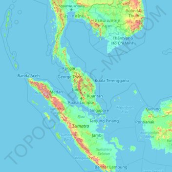
Name: Malaysia topographic map, elevation, terrain.
Location: Malaysia (0.85382 98.73651 8.38015 119.46996)
Average elevation: 54 m
Minimum elevation: -3 m
Maximum elevation: 3,191 m
Other topographic maps
Click on a map to view its topography, its elevation and its terrain.





Fort Canning Park
The hill has a long history intertwined with that of the country due to its location as the highest elevation within walking distance to the city's civic district, within the Downtown Core. It is also a popular location for exhibitions, concerts, and outdoor recreation.
Average elevation: 19 m






Bogor
The city is situated in the western part of Java island, about 53 km south of the capital Jakarta and 85 km northwest of Bandung, the administrative center of West Java Province. Bogor spreads over a basin near volcanoes Salak, which peaks at about 12 km south, and Mount Gede whose top is 22–25 km south-east…
Average elevation: 442 m



Quito
Ecuador > Pichincha > Quito Canton
Quito's elevation of 2,850 meters (9,350 ft) makes it either the highest or the second-highest national capital city in the world. This varied standing is because Bolivia is a country with multiple capitals; if La Paz is considered the Bolivian national capital, it tops the list of highest capitals, but if…
Average elevation: 2,930 m





Laguna Creek
United States > California > Sacramento County > Elk Grove > Fallbrook
Average elevation: 17 m




Moselhöhe Ediger-Eller
Germany > Rhineland-Palatinate > Landkreis Cochem-Zell > Ediger-Eller
Average elevation: 285 m