Geolocate

Bolivia topographic map

Click on the map to display elevation.

Bolivia

The sovereign state of Bolivia is a constitutionally unitary state divided into nine departments. Its geography varies as the elevation fluctuates, from the western snow-capped peaks of the Andes to the eastern lowlands, situated within the Amazon basin. One-third of the country is within the Andean mountain range. With an area of 1,098,581 km2 (424,164 sq mi), Bolivia is the fifth-largest country in South America after Brazil, Argentina, Peru and Colombia, and, alongside Paraguay, is one of two landlocked countries in the Americas. It is the 27th largest country in the world, the largest landlocked country in the Southern Hemisphere, and the seventh largest landlocked country on earth, after Kazakhstan, Mongolia, Chad, Niger, Mali, and Ethiopia.

Wikipedia (CC-BY-SA 3.0)

About this map

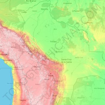
Name: Bolivia topographic map, elevation, terrain.

Location: Bolivia (-22.89827 -69.64501 -9.66894 -57.45300)

Average elevation: 1,136 m

Minimum elevation: 0 m

Maximum elevation: 6,250 m

Other topographic maps

Click on a map to view its topography, its elevation and its terrain.

Pulau Ubin

Singapore

Average elevation: 6 m

Yishun

Singapore > Yishun

Average elevation: 15 m

Tembusu Park

Singapore

Average elevation: 23 m

Pasir Ris

Singapore

Average elevation: 12 m

Jurong Island

Singapore

Average elevation: 1 m

Kent Ridge Park

Singapore > Southwest

Average elevation: 21 m

Sungei Punggol

Singapore > Central

Average elevation: 8 m

Barcelona

Spain > Catalonia > Barcelonès > Barcelona

Average elevation: 65 m

Africa

Africa's topography is a complex tapestry of plateaus, mountains, valleys, and deserts. The continent is dominated by vast plateaus, with elevations averaging around 1,000 meters (3,281 feet), especially prominent in the south and east. The Ethiopian Highlands, often referred to as the "Roof of Africa," rise…

Average elevation: 462 m

Bukit Timah Hill

Singapore > Singapore

Average elevation: 52 m

Perawang

Indonesia > Riau > Siak

Average elevation: 10 m

Khayam

Iraq > Saladin Governorate

Average elevation: 58 m

Faqra

Lebanon > Keserwan-Jbeil Governorate

Average elevation: 1,640 m

Southern Ridges

Singapore > Singapore

Average elevation: 7 m

Marina Bay

Singapore > Singapore

Average elevation: 9 m

Fort Canning Park

Singapore > Singapore

The hill has a long history intertwined with that of the country due to its location as the highest elevation within walking distance to the city's civic district, within the Downtown Core. It is also a popular location for exhibitions, concerts, and outdoor recreation.

Average elevation: 19 m

SpringLeaf Nature Park

Singapore > Singapore

Average elevation: 20 m

North Region

Singapore > Singapore

Average elevation: 32 m

Pulau Hantu Besar

Singapore > West Region

Average elevation: 1 m

Pulau Tekong

Singapore > Singapore

Average elevation: 13 m

Penang Road Open Space

Singapore > Singapore

Average elevation: 20 m

Kallang River

Singapore > Singapore

Average elevation: 26 m

Singapore River

Singapore > Singapore

Average elevation: 15 m

Hillock Park

Singapore > Singapore

Average elevation: 17 m

Wild Wild Wet

Singapore > Singapore

Average elevation: 10 m

Telok Blangah Hill

Singapore > Singapore

Average elevation: 25 m

Bidadari Park

Singapore > Southeast > Singapore

Average elevation: 17 m

Newton Circus

Singapore > Singapore

Average elevation: 19 m

Tulcea

Romania > Tulcea

Average elevation: 25 m

Pulau Hantu Kecil

Singapore > Singapore

Average elevation: 2 m

Jurong Hill Park

Singapore > Southwest

Average elevation: 11 m

Sungei Tampines

Singapore > Northeast

Average elevation: 18 m

Queenstown

Singapore > Southwest

Average elevation: 10 m

Bishan-Ang Mo Kio Park

Singapore > Singapore

Average elevation: 24 m

Jurong Central Park

Singapore > Singapore

Average elevation: 14 m

Mount Faber Park

Singapore > Singapore

Average elevation: 20 m

Clementi Woods

Singapore > Singapore

Average elevation: 15 m

Bedok Reservoir

Singapore > Northeast

Average elevation: 23 m

Singapore

Singapore > Central

Average elevation: 8 m

Gardens by the Bay

Singapore > Singapore

Average elevation: 5 m

Taipei

Taiwan

Average elevation: 207 m

Rochor River

Singapore > Central > Singapore

Average elevation: 10 m

Jurong River

Singapore > Southwest > Jurong East

Average elevation: 7 m

Geylang River

Singapore > Southeast

Average elevation: 9 m

Sungei Tongkang

Singapore > Central > Singapore

Average elevation: 18 m

Sungei Punggol

Singapore > Central

Average elevation: 8 m

Hindhede Quarry

Singapore > Northwest

Average elevation: 50 m

Shashemene

Ethiopia > Oromia Region

Average elevation: 2,053 m

Appledore

United Kingdom > England > Devon > Torridge District

Average elevation: 21 m

East Antarctica

Average elevation: 3,789 m

Kaohsiung

Taiwan

Average elevation: 14 m

Debre Markos

Ethiopia > Amhara Region > Guzamn

Debre Markos is located 300 km north-west of Addis Ababa along the Addis Ababa-Gondar road at an elevation of over 2400 meters.

Average elevation: 2,343 m

Chiang Mai

Thailand

The city is situated in a valley on a river basin in the Thai highlands and is on average at 300 m (1,000 ft) elevation. Chiang Mai's city centre sits west of the Ping River, a tributary to the Chao Phraya River, while the city's sprawl extends north-west, south-west, north-east and east of the river. To the…

Average elevation: 424 m

Odessa

Ukraine > Odesa Oblast > Odesa > Odessa

Average elevation: 20 m

Pulikamaly

India > Kerala > Kanayannur > Arakkunnam

Average elevation: 25 m

Mulanthuruthy

India > Kerala > Kanayannur

Average elevation: 12 m

Mount of Beatitudes

Israel > North District > Emek HaYarden Regional Council

The site known as the Mount of Beatitudes is on the northwestern shore of the Sea of Galilee, between Capernaum and the archeological site of Gennesaret (Ginosar), on the southern slopes of the Korazim Plateau. Its negative altitude (around 25 metres below sea level, nearly 200 metres above the Sea of Galilee)…

Average elevation: -128 m

Rocky Hill

Singapore > Southeast

Average elevation: 15 m

Yunnan Park

Singapore > Southwest

Average elevation: 19 m

Rochor Canal

Singapore > Central > Singapore

Average elevation: 15 m

Zhenghua Nature Park

Singapore > Northwest

Average elevation: 38 m

One-North Park

Singapore > Southwest

Average elevation: 25 m

Kg. Sungai Belang

Singapore > Southeast

Average elevation: 13 m

Pukura

Vanuatu > Shefa Province > Port Vila

Average elevation: 62 m

Lorong Halus

Singapore > Northeast

Average elevation: 6 m

Bogor

Indonesia > West Java > Bogor

The city is situated in the western part of Java island, about 53 km south of the capital Jakarta and 85 km northwest of Bandung, the administrative center of West Java Province. Bogor spreads over a basin near volcanoes Salak, which peaks at about 12 km south, and Mount Gede whose top is 22–25 km south-east…

Average elevation: 442 m

Verla

Finland > Kymenlaakso > Kouvola

Average elevation: 81 m

Bitoon

Philippines > Cebu > Daanbantayan

Average elevation: 9 m

Płaszewo

Poland > Słupsk County

Average elevation: 60 m

Skelton Woods

United Kingdom > England > Leeds

Average elevation: 119 m

Kathaluwa

Sri Lanka > Southern Province

Average elevation: 4 m

Doha

Qatar > Doha > Doha

Doha is located on the central-east portion of Qatar, bordered by the Persian Gulf on its coast. Its elevation is 10 m (33 ft). Doha is highly urbanized. Land reclamation off the coast has added 400 hectares of land and 30 km of coastline. Half of the 22 km² of surface area which Hamad International Airport…

Average elevation: 12 m

Morden Park

United Kingdom > England > Greater London

Average elevation: 28 m

Torrox Park

Spain > Andalusia > La Axarquía > Torrox

Average elevation: 72 m

Yasothon

Thailand

Average elevation: 130 m

Nandigama

India > Andhra Pradesh > Nandigama

Average elevation: 48 m

Benfleet

United Kingdom > England > Essex > Castle Point

Average elevation: 25 m

Mount Nebo

United States > Utah > Utah County

Average elevation: 3,115 m

Mount Timpanogos

United States > Utah > Utah County

Average elevation: 3,139 m

Sekatak Buji

Indonesia > North Kalimantan > Bulungan

Average elevation: 56 m

Mount Fuji

Japan > Sunto County > Oyama

Mount Fuji (富士山, Fujisan, Japanese: [ɸɯꜜ(d)ʑisaɴ] (listen)), located on the island of Honshū, is an active stratovolcano in Japan, with a summit elevation of 3,776.24 m (12,389 ft 3 in). It is the tallest mountain in Japan, the second-highest volcano located on an island in Asia (after Mount…

Average elevation: 3,261 m

Kamikochi

Japan > Matsumoto

Kamikōchi is a high mountain valley approximately 18 kilometers in length. The average elevation of the valley floor ranges between roughly 1,400 m (4,600 ft) above sea level at the south end and roughly 1,600 m (5,200 ft) at the northern tip.

Average elevation: 2,006 m

Karadeniz Ereğli

Turkey > Ereğli

Average elevation: 86 m

Urdaneta

Philippines > Pangasinan

Average elevation: 42 m

Tiagba

Côte d'Ivoire > Lagunes

Average elevation: 10 m

Malampuzha

India > Kerala > Palakkad

Average elevation: 101 m

Kota Kinabalu

Malaysia > Sabah

Average elevation: 86 m