
Nepal topographic map
Interactive map
Click on the map to display elevation.
Nepal
Nepal is divided into three principal physiographic belts known as Himal–Pahad–Terai. Himal is the mountain region containing snow and situated in the Great Himalayan Range; it makes up the northern part of Nepal. It contains the highest elevations in the world including 8,848.86 metres (29,032 ft) height Mount Everest (Sagarmāthā in Nepali) on the border with China. Seven other of the world's "eight-thousanders" are in Nepal or on its border with Tibet: Lhotse, Makalu, Cho Oyu, Kangchenjunga, Dhaulagiri, Annapurna and Manaslu. Pahad is the mountain region that does not generally contain snow. The mountains vary from 800 to 4,000 metres (2,600 to 13,100 ft) in altitude, with progression from subtropical climates below 1,200 metres (3,900 ft) to alpine climates above 3,600 metres (11,800 ft). The Lower Himalayan Range, reaching 1,500 to 3,000 metres (4,900 to 9,800 ft), is the southern limit of this region, with subtropical river valleys and "hills" alternating to the north of this range. Population density is high in valleys but notably less above 2,000 metres (6,600 ft) and very low above 2,500 metres (8,200 ft), where snow occasionally falls in winter. The southern lowland plains or Terai bordering India are part of the northern rim of the Indo-Gangetic Plain. Terai is the lowland region containing some hill ranges. The plains were formed and are fed by three major Himalayan rivers: the Koshi, the Narayani, and the Karnali as well as smaller rivers rising below the permanent snowline. This region has a subtropical to tropical climate. The outermost range of the foothills called Sivalik Hills or Churia Range, cresting at 700 to 1,000 metres (2,300 to 3,280 ft), marks the limits of the Gangetic Plain. Broad, low valleys called Inner Terai Valleys (Bhitri Tarai Upatyaka) lie north of these foothills in several places.
About this map
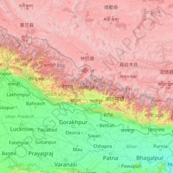
Name: Nepal topographic map, elevation, terrain.
Location: Nepal (26.34776 80.05708 30.44695 88.20153)
Average elevation: 2,583 m
Minimum elevation: 22 m
Maximum elevation: 8,152 m
Other topographic maps
Click on a map to view its topography, its elevation and its terrain.
Murree
Pakistan > Punjab > Murree District
Murree is a mountain resort city in the northernmost region of the Punjab province of Pakistan. Lying in the Galyat region of the Pir Panjal Range under the western Himalayas, it is located on the outskirts of the Islamabad–Rawalpindi metropolitan area. The town was built in the mid 19th-century and it…
Average elevation: 1,718 m
Ongole
India > Andhra Pradesh > Ongole
Ongole is located at 15.5°N 80.05°E. It has an average elevation of 10 m (33 ft) AMSL and is situated on the plains. The city is around 149 kilometres (93 mi) to the south west of Amaravati, the stat capital.
Average elevation: 15 m
Hemu River
China > Xinjiang > Burqin County > Kom-Kanas Mongolian Ethnic Township
Average elevation: 1,732 m
Abbottabad
Pakistan > Khyber Pakhtunkhwa > Abbottābād District
Abbottabad is a city in the Hazara Division of Khyber Pakhtunkhwa province, Pakistan. It is the 40th largest city in the country and 6th largest in the province by population, and serves as the headquarter of its namesake tehsil and district. It is about 120 km (75 mi) north of Islamabad-Rawalpindi and 150 km…
Average elevation: 1,363 m
Argalasti
Greece > Thessaly and Central Greece > Regional Unit of Magnesia > Municipal unit of Argalasti
Average elevation: 226 m
Doha
Doha is located on the central-east portion of Qatar, bordered by the Persian Gulf on its coast. Its elevation is 10 m (33 ft). Doha is highly urbanized. Land reclamation off the coast has added 400 hectares of land and 30 km of coastline. Half of the 22 km² of surface area which Hamad International Airport…
Average elevation: 12 m
Mount Wudang
China > Hubei > Danjiangkou City
Modern maps show the elevation of the highest of the peaks in the Wudang Shan "proper" as 1612 meters; however, the entire Wudangshan range has somewhat higher elevations elsewhere.
Average elevation: 1,172 m
Les Rieux Vieux
France > Nouvelle-Aquitaine > Haute-Vienne > Saint-Pardoux-le-Lac
Average elevation: 380 m
Dingle
On March 8, 1820, with the support of 31 cabezas de barangay of the principalía or the hispanized Christian descendants of the pre-colonial datus of Dingle and certification of the parish priest of Laglag, Fray Juan Frayle, OSA (Dingle cura párroco, 1829–1849), a petition for the re-elevation of Dingle…
Average elevation: 49 m
Pico Duarte
Dominican Republic > Santiago > San José de las Matas
Pico Duarte is the highest peak in the Dominican Republic, on the island of Hispaniola and in all the Caribbean. At 3,101 m (10,174 ft) above sea level, it gives Hispaniola the 16th-highest maximum elevation of any island in the world. Additionally, it is only 85 kilometres (53 miles) northeast of the region's…
Average elevation: 2,750 m
Jijiga
Jijiga (Somali: Jigjiga, Amharic: ጅጅጋ, Jijiga) is the capital city of Somali Region, Ethiopia. It became the capital of the Somali Region in 1995 after it was moved from Gode. Located in the Fafan Zone with 75 km (37 mi) west of the border with Somaliland, the city has an elevation of 1,634 metres above…
Average elevation: 1,732 m
Phum Trapeang Svay
Cambodia > Phnom Penh > Khan Sen Sok > Sangkat Kouk Khleang
Average elevation: 11 m
Zona Central
Chile > Maule Region > Provincia de Curicó > Teno
The topography of central Chile includes a coastal range of mountains running parallel to the Andes. Lying between the two mountain ranges is the so-called Central Valley, which contains some of the richest agricultural land in the country, especially in its northern portion. The area just north and south of…
Average elevation: 1,121 m
Ascott
United Kingdom > England > Warwickshire > Stratford-on-Avon > Whichford
Average elevation: 160 m
Jiaming Lake
Taiwan > Taitung County > Haiduan
This oval-shaped lake is located along the Southern Cross-Island Highway. The lake surface is 120 meters long and 80 meters wide at an elevation of 3,310 meters. It is surrounded by emerald green forest plantation and wildlife. The area surrounds the lake has lodges and hiking trail with a length of 13 km.
Average elevation: 3,191 m
Windhoek
Windhoek has over 300 sunny days per year. It experiences a hot semi-arid climate (BSh) according to Köppen climate classification as the annual average temperature is above 18 °C (64 °F). The temperature throughout the year would be called mild, due to altitude influence. The annual average high and low…
Average elevation: 1,679 m
Athens
Greece > Attica > Regional Unit of Central Athens
The southern section of the Athens metropolitan area (i.e., Elliniko, Athens Riviera) lies in the transitional zone between Mediterranean (Csa) and hot semi-arid climate (BSh), with its port-city of Piraeus being the most extreme example, receiving just 331.9 millimetres (13.07 in) per year. The areas to the…
Average elevation: 168 m