
Brunei topographic map
Click on the map to display elevation.
About this map
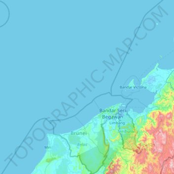
Name: Brunei topographic map, elevation, terrain.
Location: Brunei (4.00251 114.00257 5.19913 115.36356)
Average elevation: 74 m
Minimum elevation: -4 m
Maximum elevation: 2,338 m
Other topographic maps
Click on a map to view its topography, its elevation and its terrain.
Africa
Africa's topography is a complex tapestry of plateaus, mountains, valleys, and deserts. The continent is dominated by vast plateaus, with elevations averaging around 1,000 meters (3,281 feet), especially prominent in the south and east. The Ethiopian Highlands, often referred to as the "Roof of Africa," rise…
Average elevation: 462 m
Fort Canning Park
The hill has a long history intertwined with that of the country due to its location as the highest elevation within walking distance to the city's civic district, within the Downtown Core. It is also a popular location for exhibitions, concerts, and outdoor recreation.
Average elevation: 19 m
Lakhan Qasbati
Pakistan > Punjab > Rawalpindi District > Rawalpindi Cantonment
Average elevation: 512 m
Jablanica
Bosnia and Herzegovina > Federation of Bosnia and Herzegovina
The mean elevation of Jablanica is 202 metres (663 ft) above sea level. Some 69% of the municipality's land area (approx. 93 km²) is forested. Jablanica's lake ("Jablaničko") is an important geographical as well as an economic presence in Jablanica.
Average elevation: 468 m
Lalitpur
Nepal > Bagamati Province > Lalitpur
Lalitpur (Nepali: ललितपुर [ləˈlɪt̪pʊɾ]), locally known as Yala (Nepal Bhasa: 𑐫𑐮 [jəˈlʌ]) is a metropolitan city and fourth most populous city of Nepal with 299,843 inhabitants living in 77,159 households per the 2021 census. It is located in the south-central part of…
Average elevation: 1,608 m
Mount Bromo
Indonesia > East Java > Pasuruan
Further eruptions and the issuing of aviation ash advisories during the period 27–28 January 2011 led to concerns being raised regarding a volcanic ash plume, reported to be drifting eastward toward the air corridors used to access the Ngurah Rai International Airport IATA:DPS in Bali. Airport official…
Average elevation: 2,239 m
Doha
Doha is located on the central-east portion of Qatar, bordered by the Persian Gulf on its coast. Its elevation is 10 m (33 ft). Doha is highly urbanized. Land reclamation off the coast has added 400 hectares of land and 30 km of coastline. Half of the 22 km² of surface area which Hamad International Airport…
Average elevation: 12 m
Bogor
The city is situated in the western part of Java island, about 53 km south of the capital Jakarta and 85 km northwest of Bandung, the administrative center of West Java Province. Bogor spreads over a basin near volcanoes Salak, which peaks at about 12 km south, and Mount Gede whose top is 22–25 km south-east…
Average elevation: 442 m
Rinjani
Indonesia > West Nusa Tenggara
Mount Rinjani (Indonesian: Gunung Rinjani; Sasak: ᬕᬸᬦ᭄ᬗᬸᬂ᭞ᬭᬶᬦ᭄ᬚᬦᬶ, romanized: gunong rinjani) is an active stratovolcano situated in regencial North Lombok of West Nusa Tenggara province on the Indonesian island of Lombok. It reaches an elevation of 3,726 metres (12,224 ft),…
Average elevation: 3,071 m
Riyadh
It is the largest city on the Arabian Peninsula and is situated in the center of the Nafud desert, on the eastern part of the Najd plateau. The city sits at an average elevation of 600 meters (2,000 ft) above sea level, and receives around 5 million tourists each year, making it the forty-ninth most visited…
Average elevation: 630 m