
Africa topographic map
Interactive map
Click on the map to display elevation.
Africa
Africa's topography is a complex tapestry of plateaus, mountains, valleys, and deserts. The continent is dominated by vast plateaus, with elevations averaging around 1,000 meters (3,281 feet), especially prominent in the south and east. The Ethiopian Highlands, often referred to as the "Roof of Africa," rise to formidable heights, with peaks such as Ras Dejen reaching 4,550 meters (14,928 feet). The Great Rift Valley, a significant geological feature, stretches from the Red Sea down to Mozambique, creating deep depressions hosting some of Africa's largest lakes, including Lake Tanganyika and Lake Malawi, and marked by volcanic mountains such as Mount Kilimanjaro, Africa's highest point at 5,895 metres (19,341 ft) and Mount Kenya. In the northwest, the Atlas Mountains extend through Morocco, Algeria, and Tunisia, with Mount Toubkal standing as the range's highest point at 4,167 meters (13,671 feet). Contrasting these elevations, the Sahara Desert sprawls across North Africa, characterized by expansive sand dunes and rocky plateaus. The southern part of Africa includes the Kalahari Desert and the Drakensberg Mountains, which rise steeply from the plains. This diverse terrain influences the continent's climate, biodiversity, and human settlements.
About this map
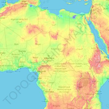
Name: Africa topographic map, elevation, terrain.
Location: Africa (-13.49757 -7.24219 36.50243 42.75781)
Average elevation: 462 m
Minimum elevation: -415 m
Maximum elevation: 4,436 m
Other topographic maps
Click on a map to view its topography, its elevation and its terrain.
Singapore
The Central Region of Singapore, encompassing approximately 132.7 square kilometers (51.2 square miles), features a diverse topography characterized by both hilly terrains and flat coastal areas. Dominating the landscape is Bukit Timah Hill, the nation's highest natural point at 164 meters (538 feet), composed…
Average elevation: 11 m
Hemu River
China > Xinjiang > Burqin County > Kom-Kanas Mongolian Ethnic Township
Average elevation: 1,732 m
Tagum
One of the significant accomplishments of the officialdom of Tagum during the 1990s was its elevation from a second to the first-class municipality. This opened a gateway to increase its financial resources through the Internal Revenue Allocation (IRA) from the national government and local revenues. This was…
Average elevation: 95 m
Singapore
Average elevation: 14 m
Qatar
Average elevation: 20 m
Exeter
United Kingdom > England > Devon
The city of Exeter was established on the eastern bank of the River Exe on a ridge of land backed by a steep hill. It is at this point that the Exe, having just been joined by the River Creedy, opens onto a wide flood plain and estuary which results in quite common flooding. Historically this was the lowest…
Average elevation: 56 m
Mount Macedon
Due to its relatively high elevation of approximately 620 metres (2,030 ft) AHD, the area experiences much cooler temperatures on average relative to nearby Melbourne. The area also receives high rainfall relative to the surrounding plains and much of the Melbourne area. This combination of geographic factors…
Average elevation: 673 m
Iran
Average elevation: 786 m
Upper Kedron
Australia > Queensland > City of Brisbane
The proposed development responds to the site's topography by offering a range of living options, ranging from bush blocks, to lots designed for terrace-style dwellings.
Average elevation: 106 m
Kunming
Kunming is at an altitude of 1,900 metres (6,234 feet) above sea level and a latitude just north of the Tropic of Cancer, and is situated in the middle of the Yunnan–Guizhou Plateau. Kunming is the fourth most populous city in Western China, after Chongqing, Chengdu, and Xi'an, and the third most populous…
Average elevation: 1,996 m
Denver
Denver's downtown district lies about 12 miles (19 kilometers) east of the foothills of the Rocky Mountains. Named after James W. Denver, the governor of the Kansas Territory at the time, Denver was founded at the confluence of Cherry Creek and the South Platte River in 1858 during the Gold Rush era. Nicknamed…
Average elevation: 1,684 m
Novi Sad
Serbia > Vojvodina > South Backa Administrative District
The city lies on the meander of the river Danube, which is only 350 meters wide beneath the marking stones of Petrovaradin. A section of the Danube-Tisza-Danube Canal marks the northern edge of the wider city centre. The main part of the city lies on the left bank of the Danube in the region of Bačka, while…
Average elevation: 83 m
Galicia
The interior of Galicia is characterized by a hilly landscape; mountain ranges rise to 2,000 m (6,600 ft) in the east and south. The coastal areas are mostly an alternate series of rias and beaches. The climate of Galicia is usually temperate and rainy, with markedly drier summers; it is usually classified as…
Average elevation: 456 m
Municipal Unit of Kranidi
Greece > Peloponnese, Western Greece and the Ionian > Argolis Regional Unit
Average elevation: 151 m
Vietnam
Due to differences in latitude and the marked variety in topographical relief, Vietnam's climate tends to vary considerably for each region. During the winter or dry season, extending roughly from November to April, the monsoon winds usually blow from the northeast along the Chinese coast and across the Gulf…
Average elevation: 173 m
Malang
Indonesia > East Java > Kota Malang
The city was capital city of Singhasari in 1222, then transferred to Dutch colony. Malang was modernized under the Dutch; its mild climate which results from its elevation, along with its proximity to the major port of Surabaya, made it a popular destination for the Dutch and other Europeans. Malang began to…
Average elevation: 490 m
Drayton St. Leonard
United Kingdom > England > Oxfordshire > South Oxfordshire
Average elevation: 54 m
Schijndel
Dutch Topographic map of the municipality of Schijndel, June 2015
Average elevation: 9 m
Malolos
Malolos is relatively flat of about 0.81% to a gently sloping of 2.17%. The slope of the land descends towards west, southwest to southern direction. The highest land elevation is at about 6.0 m (19.7 ft) above sea level while the lowest is only 0.5 m (1 ft 8 in) below sea level. A network of natural waterways…
Average elevation: 4 m
Minneapolis
United States > Minnesota > Hennepin County
A 1959 report by the US Soil Conservation Service listed Minneapolis's elevation above mean sea level as 830 feet (250 meters). The city's lowest elevation of 687 feet (209 m) above sea level is near the confluence of Minnehaha Creek with the Mississippi River. Sources disagree on the exact location and…
Average elevation: 270 m
Rishikesh
Rishikesh is at 30°06′12″N 78°17′41″E / 30.103368°N 78.294754°E / 30.103368; 78.294754. It has an average elevation of 340 metres (1,120 ft). The town is located in the Tehri Garhwal region of the northern Indian state of Uttarakhand.
Average elevation: 808 m
Tabanan
Jatiluwih is an administrative village in Penebel District, north of Tabanan; it is formed with two customary villages, Gunung Sari and Jatiluwih; under these two customary villages there are seven customary hamlets or banjar. The village is at an altitude of 700 meters. Two routes to Jatiluwih are Denpasar >…
Average elevation: 219 m
Forest City
United States > Iowa > Winnebago County
Forest City was officially founded in 1855. Formerly known as “Puckerbrush”, Robert Clark the official founder/surveyor deemed it “Forest City” because it was cut right out of the trees. It was then platted in 1856, and later incorporated on June 14, 1878. The population started to grow when immigrants…
Average elevation: 374 m
Valleseco
Valleseco is a town and a municipality of Las Palmas province, on the Canary Islands. It is in the northcentral part of Gran Canaria. Valleseco means "dry valley" in Spanish, but is actually one of the wettest municipalities of the island. Its population is 3,904 (2013), and the area is 22.11 km². The…
Average elevation: 981 m
Diego Garcia
British Indian Ocean Territory > Downtown
The island consists of the largest continuous dryland rim of all atolls in the world. The dryland rim varies in width from a few hundred metres to 2.4 km. Typical of coral atolls, it has a maximum elevation on some dunes on the ocean side of the rim of 9 metres (30 feet) above mean low water. The rim nearly…
Average elevation: 0 m