
Make a donation
Vietnam topographic map
Click on the map to display elevation.
Make a donation
Vietnam
Due to differences in latitude and the marked variety in topographical relief, Vietnam's climate tends to vary considerably for each region. During the winter or dry season, extending roughly from November to April, the monsoon winds usually blow from the northeast along the Chinese coast and across the Gulf of Tonkin, picking up considerable moisture. The average annual temperature is generally higher in the plains than in the mountains, especially in southern Vietnam compared to the north. Temperatures vary less in the southern plains around Ho Chi Minh City and the Mekong Delta, ranging from between 21 and 35 °C (70 and 95 °F) over the year. In Hanoi and the surrounding areas of the Red River Delta, the temperatures are much lower between 15 and 33 °C (59 and 91 °F). Seasonal variations in the mountains, plateaus, and the northernmost areas are much more dramatic, with temperatures varying from 3 °C (37 °F) in December and January to 37 °C (99 °F) in July and August. During winter, snow occasionally falls over the highest peaks of the far northern mountains near the Chinese border. Vietnam receives high rates of precipitation in the form of rainfall with an average amount from 1,500 to 2,000 mm (60 to 80 in) during the monsoon seasons; this often causes flooding, especially in the cities with poor drainage systems. The country is also affected by tropical depressions, tropical storms and typhoons. Vietnam is one of the most vulnerable countries to climate change, with 55% of its population living in low-elevation coastal areas.
Make a donation
About this map
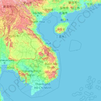
Name: Vietnam topographic map, elevation, terrain.
Location: Vietnam (7.69209 102.14386 23.39269 114.85726)
Average elevation: 173 m
Minimum elevation: -3 m
Maximum elevation: 2,808 m
Make a donation
Other topographic maps
Click on a map to view its topography, its elevation and its terrain.
Make a donation
Bandung
Indonesia > West Java > Bandung
Bandung, the capital of West Java province, located about 180 kilometres (110 mi) southeast of Jakarta, is the third-largest city in Indonesia. Its elevation is 768 metres (2,520 ft) above sea level and is surrounded by up to 2,400 metres (7,900 feet) high Late Tertiary and Quaternary volcanic terrain. The 400…
Average elevation: 879 m
Make a donation
Pljevlja
Montenegro > Pljevlja Municipality
The town lies at an altitude of 770 m (2,530 ft). In the Middle Ages, Pljevlja had been a crossroad of the important commercial roads and cultural streams, with important roads connecting the littoral with the Balkan interior. In 2023, the municipality of Pljevlja had a population of 24,134, while the city…
Average elevation: 845 m
Make a donation
Africa
Africa's topography is a complex tapestry of plateaus, mountains, valleys, and deserts. The continent is dominated by vast plateaus, with elevations averaging around 1,000 meters (3,281 feet), especially prominent in the south and east. The Ethiopian Highlands, often referred to as the "Roof of Africa," rise…
Average elevation: 462 m
Make a donation
Make a donation
Fort Canning Park
The hill has a long history intertwined with that of the country due to its location as the highest elevation within walking distance to the city's civic district, within the Downtown Core. It is also a popular location for exhibitions, concerts, and outdoor recreation.
Average elevation: 19 m
Make a donation
Make a donation
Make a donation
Make a donation
Mount of Beatitudes
Israel > North District > Emek HaYarden Regional Council
The site known as the Mount of Beatitudes is on the northwestern shore of the Sea of Galilee, between Capernaum and the archeological site of Gennesaret (Ginosar), on the southern slopes of the Korazim Plateau. Its negative altitude (around 25 metres below sea level, nearly 200 metres above the Sea of Galilee)…
Average elevation: -128 m
Make a donation
Make a donation
Make a donation
Make a donation
Make a donation
Make a donation
Make a donation
Fik'
Fiq, (Amharic: ፊቅ) (Somali pronunciation: [ˈfiːq], Somali pronunciation: [ˈfiːχ]; فیق), is a town in eastern Ethiopia. Located in the Erer Zone of the Somali Region, this town has a latitude and longitude of 08°8′N 42°18′E / 8.133°N 42.300°E / 8.133; 42.300 with an elevation of 1229 meters above sea level.
Average elevation: 1,180 m
Make a donation
Mount Fuji
Japan > Sunto County > Oyama
Mount Fuji (富士山, Fujisan, Japanese: [ɸɯꜜ(d)ʑisaɴ] (listen)), located on the island of Honshū, is an active stratovolcano in Japan, with a summit elevation of 3,776.24 m (12,389 ft 3 in). It is the tallest mountain in Japan, the second-highest volcano located on an island in Asia (after Mount…
Average elevation: 3,261 m
Gudauri
Georgia > Mtskheta-Mtianeti > Kazbegi Municipality
Gudauri (Georgian: გუდაური) is a ski resort located on the south-facing plateau of The Greater Caucasus Mountain Range in Georgia. The resort is situated in the Kazbegi Municipality, along the Georgian Military Highway near the Jvari Pass, at an elevation of 2,200 meters (7,200 ft.) above sea…
Average elevation: 2,161 m
Chiang Mai
The city is situated in a valley on a river basin in the Thai highlands and is on average at 300 m (1,000 ft) elevation. Chiang Mai's city centre sits west of the Ping River, a tributary to the Chao Phraya River, while the city's sprawl extends north-west, south-west, north-east and east of the river. To the…
Average elevation: 424 m
Make a donation
Make a donation
Make a donation
Bogor
The city is situated in the western part of Java island, about 53 km south of the capital Jakarta and 85 km northwest of Bandung, the administrative center of West Java Province. Bogor spreads over a basin near volcanoes Salak, which peaks at about 12 km south, and Mount Gede whose top is 22–25 km south-east…
Average elevation: 442 m
Make a donation
Brinchang
Brinchang (also spelt Berincang) is a town and hill resort located at an altitude of 1,540 metres (5,050 ft) in Cameron Highlands in the state of Pahang, Malaysia. The town's name is derived from nearby Gunung Brinchang, which is the second highest point in Cameron Highlands.
Average elevation: 1,524 m
Lusikisiki
South Africa > Eastern Cape > O.R. Tambo District Municipality > Ingquza Hill Local Municipality
Average elevation: 563 m
Make a donation
Lucknow
India > Uttar Pradesh > Lucknow
Lucknow stands at an elevation of approximately 123 metres (404 ft) above sea level. The city had an area of 402 km2 (155 square miles) until December 2019, when 88 villages were added to the municipal limits and the area increased to 631 km2 (244 square miles).
Average elevation: 120 m
Make a donation
Non Block High Level Conference Monument Park
Indonesia > West Java > Bandung City > Arjuna
Average elevation: 731 m
Make a donation
Make a donation