
宇治市 topographic map
Interactive map
Click on the map to display elevation.
About this map
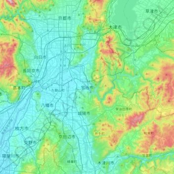
Name: 宇治市 topographic map, elevation, terrain.
Location: 宇治市, Prefectura de Kioto, 611-0021, Japón (34.73337 135.64592 35.05337 135.96592)
Average elevation: 160 m
Minimum elevation: -3 m
Maximum elevation: 784 m
Other topographic maps
Click on a map to view its topography, its elevation and its terrain.