Make a donation
Europe topographic map
Click on the map to display elevation.
Make a donation
Europe
Europe's topography is characterized by a striking contrast between its rugged southern mountains and the expansive plains of the north. The continent is often described as a "peninsula of peninsulas," featuring major peninsulas like the Iberian, Italian, and Balkan, each with unique geological features. In the southern regions, mountain ranges such as the Alps and the Pyrenees rise dramatically, with elevations frequently exceeding 9,800 feet (3,000 meters). Moving northward, the terrain gradually descends into the Great European Plain, a vast lowland stretching from the Pyrenees in the west to the Ural Mountains in the east, where most elevations are below 1,640 feet (500 meters). This plain is interspersed with rolling hills and valleys, making it one of the most agriculturally productive areas in Europe, while also being historically significant due to its accessibility for trade and invasion. The northern regions, including Scandinavia and the British Isles, are marked by fjords and rugged uplands, contributing to a diverse and complex landscape across the continent.
Make a donation
About this map
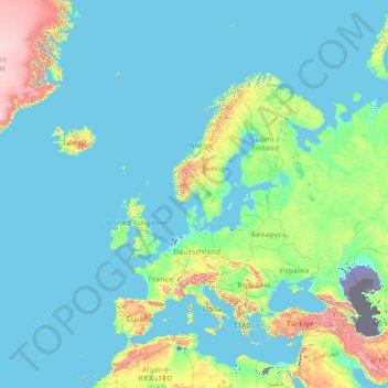
Name: Europe topographic map, elevation, terrain.
Location: Europe (26.00000 -15.00000 76.00000 35.00000)
Average elevation: 223 m
Minimum elevation: -30 m
Maximum elevation: 3,987 m
Make a donation
Other topographic maps
Click on a map to view its topography, its elevation and its terrain.
Qatar
Average elevation: 20 m
Singapore
The Central Region of Singapore, encompassing approximately 132.7 square kilometers (51.2 square miles), features a diverse topography characterized by both hilly terrains and flat coastal areas. Dominating the landscape is Bukit Timah Hill, the nation's highest natural point at 164 meters (538 feet), composed…
Average elevation: 11 m
Sarawak
Sarawak can be divided into two geological zones: the Sunda Shield, which extends southwest from the Batang Lupar River (near Sri Aman) and forms the southern tip of Sarawak, and the geosyncline region, which extends northeast to the Batang Lupar River, forming the central and northern regions of Sarawak. The…
Average elevation: 228 m
Make a donation
Singapore
Average elevation: 14 m
Monduli
A number of isolated mountains (Monduli, Lepurko, Loosimingori, and Lengai) and broad rolling plains characterize the land landscape. The heights range from 600m in the low elevations to 2900m in the high elevations. The District's vegetation includes a combination of forest, bushland, woodland grassland, and…
Average elevation: 1,369 m
Make a donation
Austin
United States > Texas > Travis County
The elevation of Austin varies from 425 feet (130 m) to approximately 1,000 feet (305 m) above sea level. Due to the fact it straddles the Balcones Fault, much of the eastern part of the city is flat, with heavy clay and loam soils, whereas the western part and western suburbs consist of rolling hills on the…
Average elevation: 216 m
Make a donation
Indonesia
Indonesia's topography is as varied as its expansive archipelago, marked by rugged mountain ranges, volcanic activity, and vast lowland plains. The majority of its major islands are mountainous, with some of the highest peaks rising above 16,000 feet (4,877 meters), such as Puncak Jaya in Papua. These…
Average elevation: 81 m
Make a donation
Make a donation
San Pedro del Pinatar
Spain > Region of Murcia > Campo de Cartagena y Mar Menor
Average elevation: 17 m
Make a donation
Make a donation
Catanduanes
The topography of Catanduanes Island is rugged and mountainous, becoming more pronounced towards the central portion of the island. Less than 10 percent of the land area has a slope gradient under 8%, mostly fractured and narrow strips of plains located along the coastal areas where most of the inhabitants are…
Average elevation: 35 m
Make a donation
Montalban
Rodriguez is generally very rough in topography, with 83% of its total land area composed of upland areas, hills and mountain ranges. The remaining 17% low-lying terrain and rolling lands are found at the south-western portion of the municipality, along with the northern portions of the Municipality of San…
Average elevation: 230 m
Make a donation
Angoulême
France > Nouvelle-Aquitaine > Charente
The earliest Cretaceous period - the Cenomanian- is in the relatively low areas (l'Houmeau, the heights of Saint-Cybard, Sillac), at an average altitude of 50m.
Average elevation: 72 m
Tirana
Albania > Central Albania > Tirana County
Tirana extends at the Plain of Tirana in the centre of Albania between the mount of Dajti in the east, the hills of Kërrabe, Sauk and Vaqarr in the south, and a valley to the north overlooking the Adriatic Sea. The average altitude is about 110 meters (360 ft) above sea level, with a maximum of 1,828 metres…
Average elevation: 146 m
Make a donation
Gera
Gera is located in a smooth-hilly landscape in eastern Thuringia at the White Elster river (progression: Saale→ Elbe→ North Sea), between the Thuringian Highland approx. 50 km (31 mi) in the south-west, the Ore Mountains approx. 50 km (31 mi) in the south-east and the Leipzig Bay approx. 50 km (31 mi) in…
Average elevation: 278 m
Make a donation
Presidio County
Geographically, Presidio County comprises 3,857 square miles (9,990 km2) of contrasting topography, geology, and vegetation. In the north and west, clay and sandy loam cover the rolling plains known as the Marfa Plateau and the Highland Country, providing good ranges of grama grasses for the widely acclaimed…
Average elevation: 1,255 m
Make a donation
Suriname
Average elevation: 152 m
Make a donation
Amur Oblast
Dwarf Siberian pine and alpine tundra grow at higher elevations and larch forests with small stands of flat-leaved birch and pine forests grow alongside the river plains. These larch and fir-spruce forests form the watershed of the Selemdzha River. The Bureya and Arkhara Rivers, southeast of the Selemdza, have…
Average elevation: 634 m
Kruja
Albania > Northern Albania > Durrës County
Krujë is found at an altitude of 600 m (1,969 ft) on the foot of Mount Krujë (Albanian: Mali i Krujës), while south and west of the town is found the plain of the Ishëm River. The town is located in the northern part of the outer Albanides tectonic unit, which consists of anticlines of Mesozoic carbonate…
Average elevation: 393 m
Municipality of Kalamata
Greece > Peloponnese Region > Messenia Regional Unit
Average elevation: 490 m
Make a donation
Thorpe on the Hill
United Kingdom > England > Lincolnshire > North Kesteven > Thorpe on the Hill
Average elevation: 17 m
Make a donation
Yokohama
Yokohama has a total area of 437.38 km2 (168.87 sq mi) at an elevation of 5 metres (16 ft) above sea level. It is the capital of Kanagawa Prefecture, bordered to the east by Tokyo Bay and located in the middle of the Kantō plain. The city is surrounded by hills and the characteristic mountain system of the…
Average elevation: 23 m
Ludford
United Kingdom > England > Lincolnshire > East Lindsey > Ludford Magna
Average elevation: 121 m
Make a donation
Make a donation
Monschau
Germany > North Rhine-Westphalia > Aachen (district)
At two meetings in the spring meet canoeists for about 50 years in Monschau international events, and a whitewater races. Nationally known is the Monschau Marathon more than 760 meters of altitude, which takes place in August.
Average elevation: 551 m
Make a donation
Make a donation
Eupen
Eupen has a cool oceanic climate with some continental influences due to it being elevated in comparison to most of Belgium. Eupen is also wetter and cloudier than Liège in the valley to the west, as a result of orographic lift due to the elevation change. As a result of this along with frequent winter…
Average elevation: 368 m
Make a donation
