
Make a donation
New Hampshire topographic map
Click on the map to display elevation.
Make a donation
New Hampshire
Average daytime highs are in the mid 70s°F to low 80s°F (24–28 °C) throughout the state in July, with overnight lows in the mid 50s°F to low 60s°F (13–15 °C). January temperatures range from an average high of 34 °F (1 °C) on the coast to overnight lows below 0 °F (−18 °C) in the far north and at high elevations. Average annual precipitation statewide is roughly 40 inches (100 cm) with some variation occurring in the White Mountains due to differences in elevation and annual snowfall. New Hampshire's highest recorded temperature was 106 °F (41 °C) in Nashua on July 4, 1911, while the lowest recorded temperature was −47 °F (−44 °C) atop Mount Washington on January 29, 1934. Mount Washington also saw an unofficial −50 °F (−46 °C) reading on January 22, 1885, which, if made official, would tie the record low for New England (also −50 °F (−46 °C) at Big Black River, Maine, on January 16, 2009, and Bloomfield, Vermont on December 30, 1933).
Make a donation
About this map
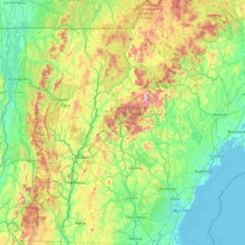
Name: New Hampshire topographic map, elevation, terrain.
Location: New Hampshire, United States (42.69723 -72.55724 45.30578 -70.56136)
Average elevation: 293 m
Minimum elevation: -4 m
Maximum elevation: 1,693 m
Make a donation
Other topographic maps
Click on a map to view its topography, its elevation and its terrain.
Taum Sauk Mountain
United States > Missouri > Iron County
Taum Sauk Mountain /ˈtɔːm ˈsɔːk/ in the Saint Francois Mountains is the highest natural point in the U.S. state of Missouri at 1,772 feet (540 m). The topography of Taum Sauk is that of an elongated ridge with a NNW-SSE orientation rather than a peak.
Average elevation: 466 m
Mount Mitchell
United States > North Carolina > Yancey County
Mount Mitchell (Attakulla in Cherokee) is the highest peak of the Appalachian Mountains and the highest peak in mainland North America east of the Mississippi River. It is located near Burnsville in Yancey County, North Carolina in the Black Mountain subrange of the Appalachians about 19 miles (31 km)…
Average elevation: 1,743 m
Make a donation
Wesley Chapel
United States > Florida > Pasco County
According to the United States Census Bureau, the CDP has a total area of 6.1 square miles (16 km2), of which 6.1 square miles (16 km2) is land and 0.04 square miles (0.10 km2) (0.49%) is water. The elevation is about 100 feet (30 m), combined with an inland location, creates more temperature variation in the…
Average elevation: 19 m
Make a donation
West Point on the Eno
United States > North Carolina > Durham County > Durham > Heritage Heights
Average elevation: 112 m
Make a donation
Make a donation
Make a donation
Pasadena
United States > Maryland > Anne Arundel County
Pasadena is located at 39°6′46″N 76°33′7″W / 39.11278°N 76.55194°W / 39.11278; -76.55194 (39.112809, −76.551871) in northern Anne Arundel County. It is bordered to the north by the city of Baltimore, to the east by the tidal Patapsco River and by Riviera Beach, to the southeast by Lake…
Average elevation: 16 m
Make a donation
Make a donation
Make a donation
Austrailia Beach
United States > Connecticut > Southeastern Connecticut Planning Region > Stonington > Mystic
Average elevation: 19 m
Make a donation
Grand Canyon
United States > Arizona > Coconino County
Uplift associated with mountain formation later moved these sediments thousands of feet upward and created the Colorado Plateau. The higher elevation has also resulted in greater precipitation in the Colorado River drainage area, but not enough to change the Grand Canyon area from being semi-arid. The uplift…
Average elevation: 1,021 m
Make a donation
Make a donation
Make a donation
Make a donation
Make a donation
Make a donation
Make a donation
Make a donation
Make a donation
Make a donation
Atlantic Coastal Plain
United States > North Carolina > Fayetteville
The province's average elevation is less than 900 meters above sea level and extends some 50 to 100 kilometers inland from the ocean. The coastal plain is normally wet, including many rivers, marsh, and swampland. It is composed primarily of sedimentary rock and unlithified sediments and is primarily used for…
Average elevation: 51 m
Make a donation
Troy Hills
United States > New Jersey > Morris County > Parsippany-Troy Hills > Troy Hills
Average elevation: 70 m
Make a donation
Make a donation
Lavon Beach Estates
United States > Texas > Collin County > Lavon Beach Estates
Average elevation: 154 m
Make a donation
Park City
United States > Utah > Summit County > Park City
In the summertime, many valley residents of the Wasatch Front visit the town to escape high temperatures. Park City is usually cooler than Salt Lake City as it lies mostly higher than 7,000 feet (2,100 m) above sea level, while Salt Lake City is situated at an elevation of about 4,300 feet (1,300 m).
Average elevation: 2,315 m
Make a donation
Miami
United States > Florida > Miami-Dade County
Miami and its suburbs are located on a broad plain between the Everglades to the west and Biscayne Bay to the east, which extends from Lake Okeechobee southward to Florida Bay. The elevation of the area averages at around 6 ft (1.8 m)[39] above sea level in most neighborhoods, especially near the coast. The…
Average elevation: 4 m