
Make a donation
North America topographic map
Click on the map to display elevation.
Make a donation
North America
North America's topography is characterized by its diverse and dramatic landscapes, stretching from the towering Rocky Mountains in the west to the expansive Great Plains in the central region, and the rugged Appalachian Mountains in the east. The Rocky Mountains, which include peaks exceeding 20,000 feet (6,096 meters), create a formidable spine that bisects the continent and contributes to significant climatic variations across the region. East of the Rockies, the Great Plains—often referred to as the "Breadbasket of North America"—are marked by vast, flat expanses of fertile soil that are ideal for agriculture, ranging from rich grasslands to rolling hills. This area is dotted with numerous rivers, including the Mississippi, which is one of the longest river systems in the world, playing a crucial role in the continent’s drainage and ecosystem. In the northeastern part of North America, the Appalachian Mountains are notable for their ancient, eroded peaks and deep valleys, while the Atlantic Coastal Plain features low-lying wetlands and sandy beaches that support diverse ecosystems. Further north, the Canadian Shield presents a rugged, rocky terrain interspersed with countless lakes formed by glacial activity, illustrating the continent's geological history.
Make a donation
About this map
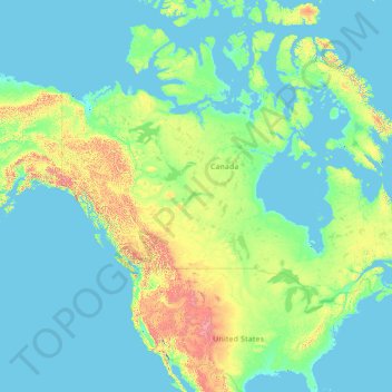
Name: North America topographic map, elevation, terrain.
Location: North America (26.00000 -134.00000 76.00000 -84.00000)
Average elevation: 294 m
Minimum elevation: -2 m
Maximum elevation: 5,837 m
Make a donation
Other topographic maps
Click on a map to view its topography, its elevation and its terrain.
Singapore
The Central Region of Singapore, encompassing approximately 132.7 square kilometers (51.2 square miles), features a diverse topography characterized by both hilly terrains and flat coastal areas. Dominating the landscape is Bukit Timah Hill, the nation's highest natural point at 164 meters (538 feet), composed…
Average elevation: 11 m
Singapore
Average elevation: 14 m
Make a donation
Indonesia
Indonesia's topography is as varied as its expansive archipelago, marked by rugged mountain ranges, volcanic activity, and vast lowland plains. The majority of its major islands are mountainous, with some of the highest peaks rising above 16,000 feet (4,877 meters), such as Puncak Jaya in Papua. These…
Average elevation: 81 m
Make a donation
Malaysia
The two parts of Malaysia, separated from each other by the South China Sea, share a largely similar landscape in that both Peninsular and East Malaysia feature coastal plains rising to hills and mountains. Peninsular Malaysia, containing 40 per cent of Malaysia's land area, extends 740 km (460 mi) from north…
Average elevation: 54 m
Make a donation
Make a donation
Makhado Local Municipality
South Africa > Limpopo > Vhembe District Municipality
Average elevation: 846 m
Germany
Germany's topography is remarkably diverse, showcasing a blend of lowlands, uplands, and mountainous regions. In the north, the North German Plain extends across vast stretches of flat, fertile land, which supports extensive agriculture, particularly wheat and dairy farming. This area is characterized by…
Average elevation: 237 m
Make a donation
Kuala Lumpur
Located in the centre of Selangor state, Kuala Lumpur was a territory of Selangor State Government. In 1974, Kuala Lumpur was split off from Selangor to form the first Federal Territory governed directly by the Malaysian federal government. Its location in the most developed state on the west coast of…
Average elevation: 80 m
Make a donation
Timberon
United States > New Mexico > Otero County
Timberon is located at 32°37′54″N 105°41′32″W / 32.63167°N 105.69222°W / 32.63167; -105.69222 (32.631675, -105.692254). Timberon is located in a forested valley, known as Sacramento Canyon, on the southern slopes of the Sacramento Mountains. The Sacramento Creek, an intermittent creek,…
Average elevation: 2,217 m
Munich
Munich lies on the elevated plains of Upper Bavaria, about 50 km (31 mi) north of the northern edge of the Alps, at an altitude of about 520 m (1,706 ft) ASL. The local rivers are the Isar and the Würm. Munich is situated in the Northern Alpine Foreland. The northern part of this sandy plateau includes a…
Average elevation: 524 m
Make a donation
Fort Canning Park
The hill has a long history intertwined with that of the country due to its location as the highest elevation within walking distance to the city's civic district, within the Downtown Core. It is also a popular location for exhibitions, concerts, and outdoor recreation.
Average elevation: 19 m
Make a donation
Make a donation
Make a donation
Mount Macedon
Due to its relatively high elevation of approximately 620 metres (2,030 ft) AHD, the area experiences much cooler temperatures on average relative to nearby Melbourne. The area also receives high rainfall relative to the surrounding plains and much of the Melbourne area. This combination of geographic factors…
Average elevation: 673 m
Make a donation
Make a donation
Make a donation
Sheffield
Sheffield nestles on the eastern foothills of the Pennines and is sculpted by a dramatic hill-and-valley system formed where five rivers — the Don, Sheaf, Rivelin, Loxley and Porter — converge, producing steep-sided valleys and gritstone ridgelines with much of the urban area built directly onto hillsides…
Average elevation: 168 m
Make a donation
Yunnan
Yunnan is situated in a mountainous area, with high elevations in the Northwest and low elevations in the Southeast. Most of the population lives in the eastern part of the province. In the west, the altitude can vary from the mountain peaks to river valleys as much as 3,000 m (9,800 ft). Yunnan is rich in…
Average elevation: 20 m
Amasra
In the late 8th century its bishop obtained from the Byzantine Emperor its elevation to the rank of autocephalous archeparchy. It is listed as such in the Notitia Episcopatuum attributed to Basil the Armenian (c. 840) and in that of Leo VI the Wise (early 10th century).
Average elevation: 121 m
Make a donation
Peneda-Gerês National Park
During the Pleistocene (approximately 1.8 to 0.001 Ma ago) climatic variations resulted in an extension of glacial fields to the mid-latitudes. While there are no remnants of glaciers now, their Ice Age products (U-shaped valleys, moraines, glacial deposits, polished and natural granite surfaces) are…
Average elevation: 629 m
Cullera
The mountain of Cullera, known as Munt de l'Or or Muntanya de l'Or, is the last mountain in the Iberian System before the Mediterranean Sea. It has an altitude of 233 meters. The historical parts of the city are to the south, and the modern tourist district is to the east, looking to the sea.
Average elevation: 18 m
Make a donation
Make a donation
Make a donation
Make a donation
Make a donation
Bairnsdale
A comprehensive geological survey of Victoria's Great Dividing Range reveals a distinct north-south alignment in its bedrock, a vestige of the bygone epochs of plate tectonics. This enduring geological framework, coupled with ongoing tectonic activity, contributes to the dynamic topography witnessed in the…
Average elevation: 25 m
Make a donation
Make a donation
Make a donation
Make a donation
Qatar
Average elevation: 20 m
Prijedor
Bosnia and Herzegovina > Republika Srpska > City of Prijedor
The urban centre of Prijedor, within the city of Prijedor, is located in the northwestern part of Bosnia and Herzegovina, on the banks of the Sana and Gomjenica rivers, and at the southwestern hills of the Kozara mountain. The area of the municipality is 833 square kilometres (322 square miles). The town is…
Average elevation: 147 m
Nurpur
India > Himachal Pradesh > Nurpur
Nurpur is located at 32°18′N 75°54′E / 32.3°N 75.9°E / 32.3; 75.9. It has an average elevation of 643 metres (2109 feet).
Average elevation: 536 m
Make a donation