
Make a donation
Greenland topographic map
Click on the map to display elevation.
Make a donation
Greenland
The lowest temperature ever recorded in the Northern Hemisphere was recorded in Greenland, near the topographic summit of the Greenland Ice Sheet, on 22 December 1991, when the temperature reached −69.6 °C (−93.3 °F). In Nuuk, the average daily temperature varies over the seasons from −5.1 to 9.9 °C (22.8 to 49.8 °F). The total area of Greenland is 2,166,086 km2 (836,330 sq mi) (including other offshore minor islands), of which the Greenland ice sheet covers 1,755,637 km2 (677,855 sq mi) (81%) and has a volume of approximately 2,850,000 km3 (680,000 cu mi). The highest point on Greenland is Gunnbjørn Fjeld at 3,700 m (12,100 ft) of the Watkins Range (East Greenland mountain range). The majority of Greenland, however, is less than 1,500 m (4,900 ft) in elevation.
Make a donation
About this map
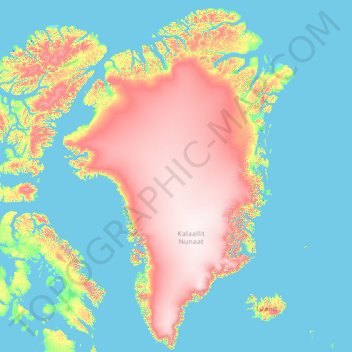
Name: Greenland topographic map, elevation, terrain.
Location: Greenland (59.51539 -74.12504 83.87517 -10.02888)
Average elevation: 594 m
Minimum elevation: -2 m
Maximum elevation: 3,433 m
Make a donation
Other topographic maps
Click on a map to view its topography, its elevation and its terrain.
Africa
Africa's topography is a complex tapestry of plateaus, mountains, valleys, and deserts. The continent is dominated by vast plateaus, with elevations averaging around 1,000 meters (3,281 feet), especially prominent in the south and east. The Ethiopian Highlands, often referred to as the "Roof of Africa," rise…
Average elevation: 462 m
Make a donation
Make a donation
Make a donation
Fort Canning Park
The hill has a long history intertwined with that of the country due to its location as the highest elevation within walking distance to the city's civic district, within the Downtown Core. It is also a popular location for exhibitions, concerts, and outdoor recreation.
Average elevation: 19 m
Make a donation
Make a donation
Make a donation
Make a donation
Make a donation
Daveyton
South Africa > Gauteng > City of Ekurhuleni Metropolitan Municipality
Average elevation: 1,613 m
Make a donation
Make a donation
Make a donation
Make a donation
Make a donation
Bogor
The city is situated in the western part of Java island, about 53 km south of the capital Jakarta and 85 km northwest of Bandung, the administrative center of West Java Province. Bogor spreads over a basin near volcanoes Salak, which peaks at about 12 km south, and Mount Gede whose top is 22–25 km south-east…
Average elevation: 442 m
Make a donation
Sur Ilots du Bas
France > Bourgogne – Franche-Comté > Haute-Saône > Renaucourt
Average elevation: 232 m
Make a donation
Bandung
Indonesia > West Java > Bandung
Bandung, the capital of West Java province, located about 180 kilometres (110 mi) southeast of Jakarta, is the third-largest city in Indonesia. Its elevation is 768 metres (2,520 ft) above sea level and is surrounded by up to 2,400 metres (7,900 feet) high Late Tertiary and Quaternary volcanic terrain. The 400…
Average elevation: 879 m
Make a donation
Make a donation
Make a donation
Make a donation
Sakleshpur
India > Karnataka > Sakaleshapura taluk
Sakleshpur is located at 12°53′35″N 75°43′30″E / 12.893°N 75.725°E / 12.893; 75.725. It has an average elevation of 932 m (3,058 ft) above mean sea level.
Average elevation: 924 m
Make a donation
Mount of Beatitudes
Israel > North District > Emek HaYarden Regional Council
The site known as the Mount of Beatitudes is on the northwestern shore of the Sea of Galilee, between Capernaum and the archeological site of Gennesaret (Ginosar), on the southern slopes of the Korazim Plateau. Its negative altitude (around 25 metres below sea level, nearly 200 metres above the Sea of Galilee)…
Average elevation: -128 m
Make a donation
Swindon
United Kingdom > England > Swindon
Swindon has an oceanic climate (Cfb in the Köppen climate classification), like the vast majority of the British Isles, with cool winters and warm summers. The nearest official weather station is RAF Lyneham, about 10 miles (16 km) west southwest of Swindon town centre. The weather station's elevation is 145…
Average elevation: 108 m
Make a donation
Agios Konstantinos
Greece > Northern Aegean > Samos Regional Unit > Municipal Unit of Vathy
Average elevation: 135 m
Chongqing
The central urban area of Chongqing, or Chongqing proper, is a city of unique features. Built on mountains and partially surrounded by the Yangtze and Jialing rivers, it is known as a "mountain city" and a "city on rivers". The night scene of the city is very illuminated, with millions of lights and their…
Average elevation: 318 m
Make a donation
Mount Fuji
Japan > Sunto County > Oyama
Mount Fuji (富士山, Fujisan, Japanese: [ɸɯꜜ(d)ʑisaɴ] (listen)), located on the island of Honshū, is an active stratovolcano in Japan, with a summit elevation of 3,776.24 m (12,389 ft 3 in). It is the tallest mountain in Japan, the second-highest volcano located on an island in Asia (after Mount…
Average elevation: 3,261 m
Doha
Doha is located on the central-east portion of Qatar, bordered by the Persian Gulf on its coast. Its elevation is 10 m (33 ft). Doha is highly urbanized. Land reclamation off the coast has added 400 hectares of land and 30 km of coastline. Half of the 22 km² of surface area which Hamad International Airport…
Average elevation: 12 m
Mount Mayon
Philippines > Albay > Tabaco
On February 23, 2023, a twin engine Cessna 340 airplane owned by the Energy Development Corporation departed Bicol International Airport in the early morning on an executive flight to the capital Manila. A few minutes after takeoff, while climbing to an altitude of 6,000 ft (1,800 m), it impacted the rocky…
Average elevation: 1,696 m
Make a donation
Europe
Europe's topography is characterized by a striking contrast between its rugged southern mountains and the expansive plains of the north. The continent is often described as a "peninsula of peninsulas," featuring major peninsulas like the Iberian, Italian, and Balkan, each with unique geological features. In…
Average elevation: 223 m
Make a donation