
Make a donation
Andorra topographic map
Click on the map to display elevation.
Make a donation
Andorra
Andorra is the sixth-smallest state in Europe, with an area of 468 square kilometres (181 sq mi) and a population of approximately 79,034. The Andorran people are a Romance ethnic group closely related to Catalans. Andorra is the world's 16th-smallest country by land and 11th-smallest by population. Its capital, Andorra la Vella, is the highest capital city in Europe, at an elevation of 1,023 metres (3,356 feet) above sea level. The official language is Catalan, but Spanish, Occitan, and French are also commonly spoken.
Make a donation
About this map
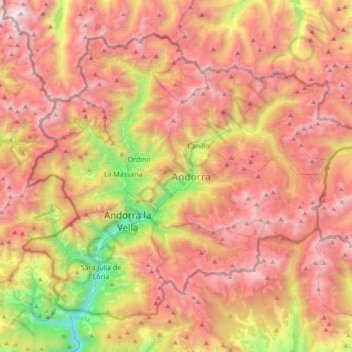
Name: Andorra topographic map, elevation, terrain.
Location: Andorra (42.42882 1.40780 42.65594 1.78687)
Average elevation: 2,084 m
Minimum elevation: 800 m
Maximum elevation: 3,103 m
Make a donation
Other topographic maps
Click on a map to view its topography, its elevation and its terrain.
Make a donation
Mount of Beatitudes
Israel > North District > Emek HaYarden Regional Council
The site known as the Mount of Beatitudes is on the northwestern shore of the Sea of Galilee, between Capernaum and the archeological site of Gennesaret (Ginosar), on the southern slopes of the Korazim Plateau. Its negative altitude (around 25 metres below sea level, nearly 200 metres above the Sea of Galilee)…
Average elevation: -128 m
Make a donation
Mount Fuji
Japan > Sunto County > Oyama
Mount Fuji (富士山, Fujisan, Japanese: [ɸɯꜜ(d)ʑisaɴ] (listen)), located on the island of Honshū, is an active stratovolcano in Japan, with a summit elevation of 3,776.24 m (12,389 ft 3 in). It is the tallest mountain in Japan, the second-highest volcano located on an island in Asia (after Mount…
Average elevation: 3,261 m
Africa
Africa's topography is a complex tapestry of plateaus, mountains, valleys, and deserts. The continent is dominated by vast plateaus, with elevations averaging around 1,000 meters (3,281 feet), especially prominent in the south and east. The Ethiopian Highlands, often referred to as the "Roof of Africa," rise…
Average elevation: 462 m
Make a donation
Make a donation
Bogor
The city is situated in the western part of Java island, about 53 km south of the capital Jakarta and 85 km northwest of Bandung, the administrative center of West Java Province. Bogor spreads over a basin near volcanoes Salak, which peaks at about 12 km south, and Mount Gede whose top is 22–25 km south-east…
Average elevation: 442 m
Mogadishu
Somalia > Banaadir > Hamar Weyne District
Mogadishu is located in or near the tropical thorn woodland biome of the Holdridge global bioclimatic scheme. The mean temperature in the city year-round is 27 °C (81 °F), with an average maximum of 30 °C (86 °F) and an average minimum of 24 °C (75 °F). Mean temperature readings per month vary by 3 °C…
Average elevation: 43 m
Make a donation
Fort Canning Park
The hill has a long history intertwined with that of the country due to its location as the highest elevation within walking distance to the city's civic district, within the Downtown Core. It is also a popular location for exhibitions, concerts, and outdoor recreation.
Average elevation: 19 m
Make a donation
Make a donation
Make a donation
Make a donation
Make a donation
Make a donation
Make a donation
Make a donation
Bandung
Indonesia > West Java > Bandung
Bandung, the capital of West Java province, located about 180 kilometres (110 mi) southeast of Jakarta, is the third-largest city in Indonesia. Its elevation is 768 metres (2,520 ft) above sea level and is surrounded by up to 2,400 metres (7,900 feet) high Late Tertiary and Quaternary volcanic terrain. The 400…
Average elevation: 879 m
Make a donation
Pljevlja
Montenegro > Pljevlja Municipality
The town lies at an altitude of 770 m (2,530 ft). In the Middle Ages, Pljevlja had been a crossroad of the important commercial roads and cultural streams, with important roads connecting the littoral with the Balkan interior. In 2023, the municipality of Pljevlja had a population of 24,134, while the city…
Average elevation: 845 m
Make a donation
Make a donation
Fik'
Fiq, (Amharic: ፊቅ) (Somali pronunciation: [ˈfiːq], Somali pronunciation: [ˈfiːχ]; فیق), is a town in eastern Ethiopia. Located in the Erer Zone of the Somali Region, this town has a latitude and longitude of 08°8′N 42°18′E / 8.133°N 42.300°E / 8.133; 42.300 with an elevation of 1229 meters above sea level.
Average elevation: 1,180 m
Make a donation
Make a donation
Make a donation
Make a donation
Make a donation
Gudauri
Georgia > Mtskheta-Mtianeti > Kazbegi Municipality
Gudauri (Georgian: გუდაური) is a ski resort located on the south-facing plateau of The Greater Caucasus Mountain Range in Georgia. The resort is situated in the Kazbegi Municipality, along the Georgian Military Highway near the Jvari Pass, at an elevation of 2,200 meters (7,200 ft.) above sea…
Average elevation: 2,161 m
Chiang Mai
The city is situated in a valley on a river basin in the Thai highlands and is on average at 300 m (1,000 ft) elevation. Chiang Mai's city centre sits west of the Ping River, a tributary to the Chao Phraya River, while the city's sprawl extends north-west, south-west, north-east and east of the river. To the…
Average elevation: 424 m
Make a donation
Daveyton
South Africa > Gauteng > City of Ekurhuleni Metropolitan Municipality
Average elevation: 1,613 m
Make a donation
Brinchang
Brinchang (also spelt Berincang) is a town and hill resort located at an altitude of 1,540 metres (5,050 ft) in Cameron Highlands in the state of Pahang, Malaysia. The town's name is derived from nearby Gunung Brinchang, which is the second highest point in Cameron Highlands.
Average elevation: 1,524 m
Lusikisiki
South Africa > Eastern Cape > O.R. Tambo District Municipality > Ingquza Hill Local Municipality
Average elevation: 563 m
Make a donation
Lucknow
India > Uttar Pradesh > Lucknow
Lucknow stands at an elevation of approximately 123 metres (404 ft) above sea level. The city had an area of 402 km2 (155 square miles) until December 2019, when 88 villages were added to the municipal limits and the area increased to 631 km2 (244 square miles).
Average elevation: 120 m
Make a donation