
Make a donation
Labuan topographic map
Click on the map to display elevation.
Make a donation
About this map
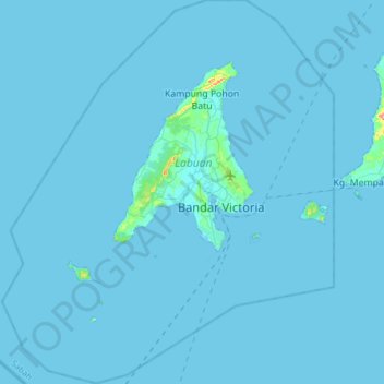
Name: Labuan topographic map, elevation, terrain.
Location: Labuan, Malaysia (5.13667 115.06833 5.44167 115.33333)
Average elevation: 1 m
Minimum elevation: 0 m
Maximum elevation: 99 m
Make a donation
Other topographic maps
Click on a map to view its topography, its elevation and its terrain.
Make a donation
Make a donation
Genting Highlands
Genting Highlands is a hill station located on the peak of Mount Ulu Kali in the Titiwangsa Mountains, central Peninsular Malaysia, at 1800 metres elevation. Located in the state of Pahang, it was established in 1965 by the late Malaysian businessman Lim Goh Tong. The primary tourist attraction is Resorts…
Average elevation: 1,517 m
Make a donation
Make a donation
Make a donation
Make a donation
Make a donation
Make a donation
Make a donation
Kampung Baru Batu Caves
Malaysia > Selangor > Selayang Municipal Council > Batu Caves
Average elevation: 68 m
Make a donation
Make a donation
Make a donation
Make a donation
Make a donation
Make a donation
Make a donation
Make a donation
Make a donation
Make a donation
Kampung Indah Permai
Malaysia > Selangor > Ampang Jaya Municipal Council > Kampung Indah Permai
Average elevation: 137 m
Hulu Kelang
Malaysia > Selangor > Ampang Jaya Municipal Council > Hulu Kelang
Average elevation: 147 m
Make a donation
Make a donation
Make a donation
Cameron Highlands
Surveyed by the government geologist and explorer William Cameron in 1885, the outpost consists of three mukims (subdistricts), namely Ringlet, Tanah Rata and Ulu Telom. Its eight settlements are Ringlet, Tanah Rata (the administrative centre), Brinchang, the Bertam Valley, Kea Farm, Tringkap, Kampung Kuala…
Average elevation: 1,400 m
Make a donation
Make a donation