Geolocate

Sarawak topographic map

Interactive map

Click on the map to display elevation.

Sarawak

Sarawak can be divided into two geological zones: the Sunda Shield, which extends southwest from the Batang Lupar River (near Sri Aman) and forms the southern tip of Sarawak, and the geosyncline region, which extends northeast to the Batang Lupar River, forming the central and northern regions of Sarawak. The oldest rock type in southern Sarawak is schist formed during the Carboniferous and Lower Permian times, while the youngest igneous rock in this region, andesite, can be found at Sematan. Geological formation of the central and northern regions started during the late Cretaceous period. Other types of stone that can be found in central and northern Sarawak are shale, sandstone, and chert. The Miri Division in eastern Sarawak is the region of Neogene strata containing organic rich rock formations which are the prolific oil and gas reserves. The rocks enriched in organic components are mudstones in Lambir, Miri and Tukau Formations of Middle Miocene-Lower Pliocene age. Significant quantities of Sarawak soil are lithosols, up to 60 per cent, and podsols, around 12 per cent, while abundant alluvial soil is found in coastal and riverine regions. 12 per cent of Sarawak is covered with peat swamp forest. Limestone with well-developed karst topography and cave systems is found scattered from west to east Sarawak, but concentrated in certain regions such as in the Bau district in the west and southwards near the Kalimantan border.

Wikipedia (CC-BY-SA 3.0)

About this map

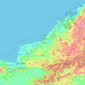
Name: Sarawak topographic map, elevation, terrain.

Location: Sarawak, Malaysia (0.85382 109.53804 5.10833 115.67803)

Average elevation: 228 m

Minimum elevation: -4 m

Maximum elevation: 2,148 m

Other topographic maps

Click on a map to view its topography, its elevation and its terrain.

Togop Darat

Malaysia > Sabah > Ranau

Average elevation: 288 m

Bukit Janda Baik

Malaysia > Pahang

Average elevation: 552 m

Genting Sempah

Malaysia > Pahang

Average elevation: 718 m

Kampong Tulang

Malaysia > Sarawak > Miri

Average elevation: 3 m

Kota Kinabalu

Malaysia > Sabah

Average elevation: 86 m

Seremban

Malaysia > Negeri Sembilan

Average elevation: 168 m

Sungai Lalang

Malaysia > Kedah

Average elevation: 19 m

Bukit Selambau

Malaysia > Kedah

Average elevation: 35 m

Sungai Kisau

Malaysia > Sarawak > Tebedu > Kampung Daha Mawang

Average elevation: 101 m

Kampung Sukang Sugut

Malaysia > Sabah > Beluran

Average elevation: 31 m

Kampung Kujang Sain

Malaysia > Sarawak > Tebedu

Average elevation: 109 m

Kampung Sondoton Baru

Malaysia > Sabah > Keningau > Keningau

Average elevation: 318 m

Kampung Muhibbah

Malaysia > Sabah > Beaufort

Average elevation: 26 m

Kuala Pilah

Malaysia > Negeri Sembilan

Average elevation: 123 m

Bukit Merah

Malaysia > Perak

Average elevation: 12 m

Kahang

Malaysia > Johor

Average elevation: 27 m

Gurun

Malaysia > Kedah

Average elevation: 134 m

Bidor

Malaysia > Perak

Average elevation: 51 m

Merbok

Malaysia > Kedah

Average elevation: 130 m

Pulai

Malaysia > Johor > Iskandar Puteri

Average elevation: 25 m

Mela

Malaysia > Pahang

Average elevation: 81 m

Kampung Sekolah

Malaysia > Johor > Pagoh

Average elevation: 26 m

Alor Gajah

Malaysia > Malacca

Average elevation: 56 m

Kampung Simon

Malaysia > Johor > Teluk Ramunia

Average elevation: 6 m

Chemor

Malaysia > Perak

Average elevation: 106 m

Desa Tahang Rimau

Malaysia > Johor > Segamat

Average elevation: 24 m

Pekan Nanas

Malaysia > Johor

Average elevation: 16 m

Kampung Gebeng

Malaysia > Pahang

Average elevation: 5 m

Likas

Malaysia > Sabah

Average elevation: 10 m

Kulai

Malaysia > Johor

Average elevation: 44 m

FELDA Gedangsa

Malaysia

Average elevation: 41 m

Kampung Sahom

Malaysia > Perak

Average elevation: 271 m

Pantai

Malaysia > Negeri Sembilan

Average elevation: 109 m

Kampung Rantau Panjang

Malaysia > Selangor

Average elevation: 15 m

Bukit Segenting

Malaysia > Johor > Batu Pahat

Average elevation: 4 m

Kampung Padang Balang

Malaysia > Kuala Lumpur

Average elevation: 51 m

Kampung Batu 10 Labu

Malaysia > Negeri Sembilan > Labu

Average elevation: 51 m

Kuala Muda

Malaysia > Kedah

Average elevation: 800 m

Seri Iskandar

Malaysia > Perak

Seri Iskandar (Jawi: سري إسكندر, Chinese: 斯里依斯干达) is a town and capital of Perak Tengah District in Perak, Malaysia. It is located about 40 km southwest of Ipoh on the main Ipoh-Lumut highway, at an average elevation of 29 meters above the sea level. A branch campus of Universiti Teknologi…

Average elevation: 29 m

Genting Highlands

Malaysia > Pahang

Genting Highlands is a hill station located on the peak of Mount Ulu Kali in the Titiwangsa Mountains, central Peninsular Malaysia, at 1800 metres elevation. Located in the state of Pahang, it was established in 1965 by the late Malaysian businessman Lim Goh Tong. The primary tourist attraction is Resorts…

Average elevation: 1,517 m

Temangan

Malaysia > Kelantan

Average elevation: 31 m

Kampung Ah Siang

Malaysia > Johor > Johor Bahru

Average elevation: 15 m

Sungai Besar

Malaysia > Selangor

Average elevation: 3 m

Kuching

Malaysia > Sarawak > Kuching

Average elevation: 17 m

Siburan

Malaysia > Sarawak > Kuching

Average elevation: 27 m

FELDA Tenggaroh 2

Malaysia > Johor

Average elevation: 37 m

Gemas

Malaysia > Negeri Sembilan

Average elevation: 42 m

Bintulu

Malaysia > Sarawak

Average elevation: 18 m

Mount Ophir

Malaysia > Johor

Average elevation: 840 m

Tanah Rata Park

Malaysia > Pahang > Cameron Highlands

Average elevation: 1,462 m

Kampung Mawai Baharu

Malaysia > Johor > Mawai

Average elevation: 21 m

Rengit

Malaysia > Johor

Average elevation: 2 m

Gunung Belumut

Malaysia > Johor

Average elevation: 639 m

Kampung Santubong

Malaysia > Sarawak

Average elevation: 70 m

Kampung Simpang Tiga

Malaysia > Perak > Bidor

Average elevation: 46 m

Gunung Raya

Malaysia > Kedah

Average elevation: 480 m

Segamat

Malaysia > Johor

Average elevation: 33 m

Kuala Tahan

Malaysia > Pahang

Average elevation: 131 m

Taiping

Malaysia > Perak

Average elevation: 193 m

Cameron Highlands

Malaysia > Pahang

Surveyed by the government geologist and explorer William Cameron in 1885, the outpost consists of three mukims (subdistricts), namely Ringlet, Tanah Rata and Ulu Telom. Its eight settlements are Ringlet, Tanah Rata (the administrative centre), Brinchang, the Bertam Valley, Kea Farm, Tringkap, Kampung Kuala…

Average elevation: 1,400 m

Kampung Bok Bak

Malaysia > Kedah

Average elevation: 157 m

Kampung Ulu Perting

Malaysia > Pahang > Bentong

Average elevation: 143 m

Tanjung Penyusuh

Malaysia > Johor > Tanjung Sepang

Average elevation: 2 m

Raub

Malaysia > Pahang > Raub

Average elevation: 218 m

Kanthan

Malaysia > Perak > Kanthan

Average elevation: 84 m

Hutan Melintang

Malaysia > Perak > Hutan Melintang

Average elevation: 3 m

Sungai Salak

Malaysia > Selangor > Sepang

Average elevation: 26 m

Batang Kali

Malaysia > Selangor

Average elevation: 65 m

Tebrau

Malaysia > Johor

Average elevation: 25 m

Kerteh

Malaysia > Terengganu > Kemaman District > Kerteh

Average elevation: 27 m

Semenyih Dam

Malaysia > Selangor > Kajang

Average elevation: 190 m

Cyberjaya

Malaysia > Selangor > Cyberjaya

Average elevation: 24 m

Sedenak

Malaysia > Johor > Sedenak

Average elevation: 56 m

River of Life

Malaysia > Kuala Lumpur

Average elevation: 51 m

Jenjarom

Malaysia > Selangor > Jenjarom

Average elevation: 4 m

Pengerang

Malaysia > Johor > Pengerang

Average elevation: 6 m

Port Dickson

Malaysia > Negeri Sembilan > Port Dickson

Average elevation: 12 m

Pelangi Semenyih

Malaysia > Selangor > Pelangi Semenyih

Average elevation: 53 m

Section 19

Malaysia > Selangor > SA > Section 19

Average elevation: 10 m

Section 1

Malaysia > Selangor > SA > Section 1

Average elevation: 17 m

Tikus Island

Malaysia > Tikus Island

Average elevation: 2 m

Kampung Momo

Malaysia > Negeri Sembilan > Nilai

Average elevation: 43 m

Kota Raja

Malaysia > Selangor > SA > Kota Raja

Average elevation: 10 m

Hulu Yam Lama

Malaysia > Selangor > Hulu Yam Lama

Average elevation: 51 m

Pulau Manis

Malaysia > Pahang > Pulau Manis

Average elevation: 46 m

Malaysia

Malaysia

Average elevation: 80 m

Kuala Klawang

Malaysia > Negeri Sembilan > Kuala Klawang

Average elevation: 190 m

Batu Pahat

Malaysia > Johor > Batu Pahat

Average elevation: 10 m