
Perak topographic map
Interactive map
Click on the map to display elevation.
Perak
In 1959, a British artillery officer stationed at an inland army base during the Malayan Emergency discovered the Tambun rock art, identified by archaeologists as the largest rock art site in the Malay Peninsula. Most of the paintings are located high above the cave floor, at an elevation of 6–10 metres (20–33 ft). Seashells and coral fragments scattered along the cave floor are evidence that the area was once underwater.
About this map
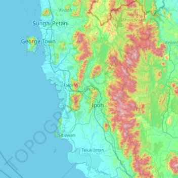
Name: Perak topographic map, elevation, terrain.
Location: Perak, Malaysia (3.66754 100.36129 5.93439 101.75333)
Average elevation: 251 m
Minimum elevation: -1 m
Maximum elevation: 2,127 m
Other topographic maps
Click on a map to view its topography, its elevation and its terrain.
Seri Iskandar
Seri Iskandar (Jawi: سري إسكندر, Chinese: 斯里依斯干达) is a town and capital of Perak Tengah District in Perak, Malaysia. It is located about 40 km southwest of Ipoh on the main Ipoh-Lumut highway, at an average elevation of 29 meters above the sea level. A branch campus of Universiti Teknologi…
Average elevation: 29 m
Genting Highlands
Genting Highlands is a hill station located on the peak of Mount Ulu Kali in the Titiwangsa Mountains, central Peninsular Malaysia, at 1800 metres elevation. Located in the state of Pahang, it was established in 1965 by the late Malaysian businessman Lim Goh Tong. The primary tourist attraction is Resorts…
Average elevation: 1,517 m
Kampung Baru Batu Caves
Malaysia > Selangor > Selayang Municipal Council > Batu Caves
Average elevation: 68 m
Cameron Highlands
Surveyed by the government geologist and explorer William Cameron in 1885, the outpost consists of three mukims (subdistricts), namely Ringlet, Tanah Rata and Ulu Telom. Its eight settlements are Ringlet, Tanah Rata (the administrative centre), Brinchang, the Bertam Valley, Kea Farm, Tringkap, Kampung Kuala…
Average elevation: 1,400 m